Latitude And Longitude Map of India | Where is India?

India is considered a part of South Asia. The Country is Officially Called the Republic of India and has an extensive coastline. With the Indian Ocean in the south and the Bay of Bengal in the southeast, the Arabian Sea is southwest of India. Myanmar, Bangladesh, Pakistan, Bhutan, China, and Nepal surround India as well. India latitude and longitude Map is 22° 00′ N and 77° 00′ E . Below is the map of India showing major towns, roads, and airports with latitudes and longitudes plotted on it.
India covers 2,973,193 square kilometers of land and 314,070 square kilometers of water, making it the 7th largest nation in the world with a total area of 3,287,263 square kilometers. The population of India is 1,205,073,612 (2012) and the nation has a density of 405 people per square kilometer. The currency of India is the Indian Rupee (INR). As well, the people of India are referred to as Indians.
Quick Facts
| Population | 1,205,073,612 |
| Density | 405.3 / km2 ( 1,049.8 / mi2 ) |
| Languages | Hindi, English |
| Independence Year | 1947 |
| Capital | New Delhi |
| Currency | Indian Rupee |
| GDP | 2,070,000,000,000 (2014 data) |
| GDP per Capita | 1,718 (2014 data) |
| Land Area | 2,973,193 km2 (1,147,956 mi2) |
| Water Area | 314,070 km2 (121,263 mi2) |
| Neighboring Countries | China, Nepal, Bangladesh, Bhutan, Myanmar, Pakistan |
| Minimum Longitude | 68.170 |
| Maximum Longitude | 97.400 |
| Minimum Latitude | 6.750 |
| Maximum Latitude | 35.990 |
Where is India?

Latitude and Longitude of India With All States
India is a land of great diversity, with a rich history and culture. The country is home to a wide variety of landscapes, from the snow-capped peaks of the Himalayas to the lush green hills of the Deccan Plateau. India is also home to a wide variety of people, from the Hindus who make up the majority of the population to the Muslims, Christians, Sikhs, and Buddhists who make up the minority. India lies to the north of the equator between 6° 44′ and 35° 30′ north latitude and 68° 7′ and 97° 25′ east longitude. The country of India is on the Asia continent and a latitude of 20.5937° N, and a longitude of 78.9629° E.
| States Name | Latitude | Longitude |
|---|---|---|
| Tamil Nadu, India | 11.059821 | 78.387451 |
| Telangana, India | 17.123184 | 79.208824 |
| Madhya Pradesh, India | 23.473324 | 77.947998 |
| Haryana, India | 29.238478 | 76.431885 |
| Chhattisgarh, India | 21.295132 | 81.828232 |
| Haryana, India | 29.065773 | 76.040497 |
| Bhitarwar, Madhya Pradesh, India | 25.794033 | 78.116531 |
| Maharashtra, India | 19.601194 | 75.552979 |
| Tripura, India | 23.745127 | 91.746826 |
| Chandoor, Telangana, India | 17.874857 | 78.100815 |
| Karnataka, India | 15.317277 | 75.713890 |
| Kerala, India | 10.850516 | 76.271080 |
| Uttar Pradesh, India | 28.207609 | 79.826660 |
| Assam, India | 26.244156 | 92.537842 |
| Maharashtra, India | 19.663280 | 75.300293 |
| Tamil Nadu, India | 11.127123 | 78.656891 |
| Karnataka, India | 15.317277 | 75.713890 |
| West Bengal, India | 22.978624 | 87.747803 |
| Gujarat, India | 22.309425 | 72.136230 |
| Odisha, India | 20.940920 | 84.803467 |
| Rajasthan, India | 27.391277 | 73.432617 |
| Himachal Pradesh, India | 32.084206 | 77.571167 |
The latitude and the longitude of New Delhi the capital of India are 28° 36′ N and 77° 12′ E respectively. The time followed in India is noticed as UTC+5.5.
✅How do I find India Latitude and Longitude Map?
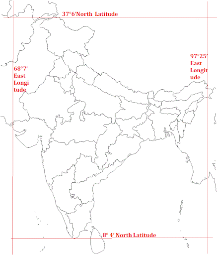
India is a vast country. Lying entirely in the Northern hemisphere (Figure 1.1) the mainland extends between latitudes 8°4’N and 37°6’N and longitudes 68°7’E and 97°25’E.
✅How can I find Location of India?
India is situated in the continent of Asia. It lies completely in the Northern hemisphere and Eastern hemisphere between latitudes 84′ N and 37°6’N and longitudes 68°7′ E and 97°25′ E. India is divided by the Tropic of Cancer 23°30′ N in almost two equal parts. Latitude and longitude of India.
Latitude And Longitude Map of India | Where is India? is the Map of India . You can also free download Map images HD Wallpapers for use desktop and laptop.
India is a vast country and is also the seventh-largest country of the world in terms of area. India is situated in the northern hemisphere (north of the equator line) and in the eastern hemisphere (east of Prime Meridian). New Delhi is the capital city of India. It has a population of 317,797 and is located on a latitude of 28.64 and a longitude of 77.22. New Delhi is also the political center of India, which is considered a Republic, and home to its Ceremonial head of state.
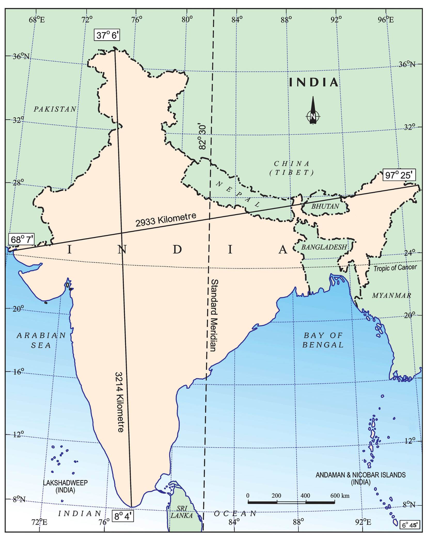
In the north, India extends to a latitudinal coordinate of 35°30' N. This point is positioned on the Siachen Glacier, which is located in the Himalayas. The southern point on the mainland of India is at a latitudinal coordinate of 08°06' N. This point is in the city of Kanyakumari, in the state of Tamil Nadu. To the east, India reaches a longitude of 97°20' E. The most extreme point in eastern India is in a city called Kibithu, found in the Indian state of Arunachal Pradesh. To the west, India’s furthest point is Sir Creek, known as an estuary. With a coordinate of 68°03' E, this point is in the Indian state of Gujarat.