Mississippi River Map | US Major River Map

Mississippi River Map | US Major River Map is the Map of United States of America. You can also free download United States of America Map images HD Wallpapers for use desktop and laptop. Click Printable Large Map
The Mississippi River is the 2nd longest river in North America. It has a total length of 2,339 miles (3,765 km) from its source to the sea. It starts flowing in the state of Minnesota and flows south to the Gulf of Mexico. The River is used primarily for transportation and it is an important commercial waterway across the globe. It connects many cities and has long been an important part of American trade.
The Missouri River is about 100 miles long and it is a tributary of the Mississippi River. According To Some Sources, the US Mississippi River Map as being the third-longest river system in the world if the length of the Missouri and Ohio Rivers are added to the Mississippi’s main stem.
At its headwaters, Lake Itasca in Minnesota, the river’s depth is 18 inches (3 feet). It’s the shallowest point of the river. The deepest point is Algiers Point in New Orleans, Louisiana where it is 200 feet deep (61 meters). At the headwaters of the Mississippi, the average surface speed of the water is about 1.2 miles per hour – roughly one-half as fast as people walk. In New Orleans, the river flows at about three miles per hour.
Map of USA With Rivers and Mountains

List of Longest Rivers of the United States
| # | Name | Mouth | Length | Discharge |
| 1 | Missouri River | Mississippi River | 2,341 mi 3,768 km |
69,100 ft3/s 1,956 m3/s |
| 2 | Mississippi River | Gulf of Mexico | 2,202 mi 3,544 km |
650,000 ft3/s 18,400 m3/s |
| 3 | Yukon River | Bering Sea | 1,979 mi 3,185 km |
224,000 ft3/s 6,340 m3/s |
| 4 | Rio Grande | Gulf of Mexico | 1,759 mi 2,830 km |
1,300 ft3/s 37 m3/s |
| 5 | Colorado River | Gulf of California | 1,450 mi 2,330 km |
1,400 ft3/s 40 m3/s |
| 6 | Arkansas River | Mississippi River | 1,443 mi 2,322 km |
35,500 ft3/s 1,004 m3/s |
| 7 | Columbia River | Pacific Ocean | 1,243 mi 2,000 km |
273,000 ft3/s 7,730 m3/s |
| 8 | Red River | Atchafalaya and Mississippi rivers | 1,125 mi 1,811 km |
30,100 ft3/s 852 m3/s |
| 9 | Snake River | Columbia River | 1,040 mi 1,674 km |
55,300 ft3/s 1,565 m3/s |
| 10 | Ohio River | Mississippi River | 979 mi 1,575 km |
308,400 ft3/s 8,733 m3/s |
✅US Map With Mountains and Rivers
The words “Mountain States” generally refer to the U.S. States which encompass the U.S. Rocky Mountains. These are oriented north-south through portions of the states of Montana, Idaho, Wyoming, Colorado, Utah, and New Mexico.
✅What Are Geographical Features of the United States?
- Appalachian Mountains.
- Rocky Mountains.
- Great Salt Lake.
- Grand Canyon.
- Great Plains.
- Mississippi River.
- Mojave Desert & Death Valley.
Map of USA With Rivers And Mountains
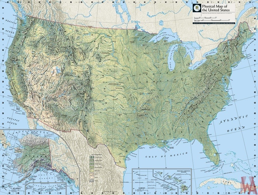
Major rivers in the Map of USA include the Mississippi, the Missouri, the Colorado, the Arkansas, and the Columbia. Mississippi river is a Part of the longest river system in the United States, the Mississippi Rivers Map runs from Minnesota down to New Orleans, Louisiana, where it drains into the Gulf of Mexico. Along the way, the Mississippi drains part of 31 different states.
Reference:


