State Wise Large Color Map of the USA

State Wise Large Color Map of the USA is the Map of United States of America. You can also free download United States of America Map images HD Wallpapers for use desktop and laptop. Click Printable Large Map
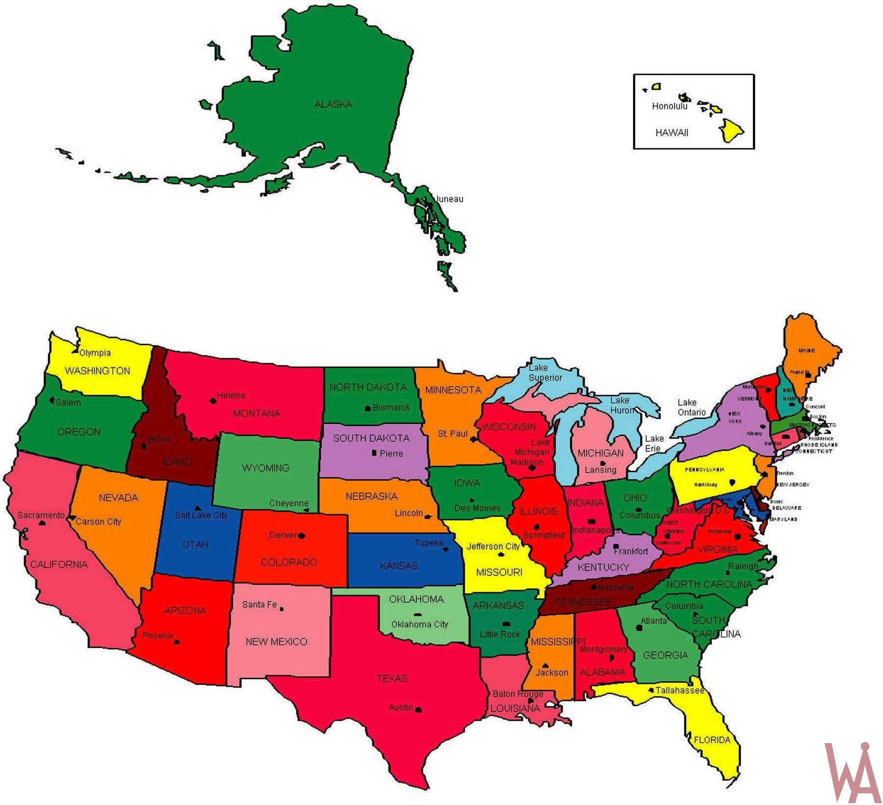
The Map of the USA consists of 50 states and a federal district. The USA has 48 contiguous states and the federal district of Washington, D.C. is positioned in central North America between Canada and Mexico. The state of Alaska is west of Canada and east of Russia across the Bering Strait, and the state of Hawaii is in the mid-North Pacific On the Large Map of the USA. USA country also has five populated and nine unpopulated territories in the Pacific and the Caribbean.
The United States covers an area of 9,833,516 km², making it the third-largest country in the world. The most populous country in America is home to more than 330 million people (in 2020). The capital city is Washington, D.C.; its largest city is New York. Spoken languages are English 80%, and Spanish 13%.
Large State Color Map of US
With this color map of the United States, we can learn about the regions of the United States, where they are located, and label the states.
State Map of the USA

The 50 States of the USA
- Alabama (AL)
- Alaska (AK)
- Arizona (AZ)
- Arkansas (AR)
- California (CA)
- Colorado (CO)
- Connecticut (CT)
- Delaware (DE)
- Florida (FL)
- Georgia (GA)
- Hawaii (HI)
- Idaho (ID)
- Illinois (IL)
- Indiana (IN)
- Iowa (IA)
- Kansas (KS)
- Kentucky (KY)
- Louisiana (LA)
- Maine (ME)
- Maryland (MD)
- Massachusetts (MA)
- Michigan (MI)
- Minnesota (MN)
- Mississippi (MS)
- Missouri (MO)Montana (MT)
- Nebraska (NE)
- Nevada (NV)
- New Hampshire (NH)
- New Jersey (NJ)
- The New Mexico (NM)
- New York (NY)
- North Carolina (NC)
- North Dakota (ND)
- Ohio (OH)
- Oklahoma (OK)
- Oregon (OR)
- Pennsylvania (PA)
- Rhode Island (RI)
- South Carolina (SC)
- South Dakota (SD)
- Tennessee (TN)
- Texas (TX)
- Utah (UT)
- Vermont (VT)
- Virginia (VA)
- Washington (WA)
- West Virginia (WV)
- Wisconsin (WI)
- Wyoming (WY)
This State Map of the USA highlights state boundaries and important cities. This State color map of the USA also points out the most popular attractions. It is a great guide for spotting the natural wonders in the US, ranging from Niagara Falls to the Redwood National Forest, and Yosemite National Park to Yellowstone National Park.

Interesting state facts of the USA States
- Alaska is the largest state in the USA by area, and it is also the most sparsely populated. It is home to Denali, the tallest mountain peak in North America, and Wrangell-St. Elias National Park & Preserve, which is larger than nine US states combined.
- California is the most populous state in the USA, and it is also one of the most diverse. It is home to Hollywood, Silicon Valley, and many other iconic landmarks. California is also a major agricultural producer, and it is the leading producer of wine in the USA.
- Florida is known for its beaches, theme parks, and subtropical climate. It is also home to the Everglades National Park, which is the largest subtropical wilderness in the USA.
- Hawaii is the only island state in the USA, and it is home to six of the world’s most active volcanoes. Hawaii is also a popular tourist destination, known for its beautiful beaches, lush rainforests, and unique culture.
- Illinois is home to Chicago, one of the largest cities in the USA. Chicago is known for its deep-dish pizza, its architecture, and its world-class museums. Illinois is also a major agricultural producer, and it is the leading producer of soybeans in the USA.
- Louisiana is known for its Cajun and Creole culture, its unique cuisine, and its Mardi Gras celebrations. Louisiana is also a major oil and gas producer, and it is home to the Mississippi River Delta, which is the largest wetland ecosystem in the USA.
- New York is home to New York City, one of the most iconic cities in the world. New York City is known for its skyscrapers, its Broadway shows, and its diverse population. New York is also a major financial center, and it is home to the New York Stock Exchange.
- Texas is the second largest state in the USA by area, and it is also the second most populous state. Texas is known for its oil and gas industry, its barbecue, and its cowboy culture. Texas is also home to Alamo, a historic mission and fortress that played a pivotal role in the Texas Revolution.
✅Color Map of the United States
With this color map of the United States, we can learn about the regions of the United States, where they are located, and label the states.
✅USA Map State Wise
There are fifty (50) states and Washington D.C.The last two states to join the Union were Alaska (49th) and Hawaii (50th). There are 50 stars representing the 50 states and there are 13 stripes representing the 13 original colonies.
Color Map of the USA
This State Wise Large Color Map of the USA showing the two-letter abbreviation for each state with the state name next to it. Knowing the abbreviations of each is vital for sending and receiving mail and packages from anywhere in the US, or even in the world.
Reference:


