Map of New Jersey | Political, County, Geography, Transportation, And Cities Map

Map of New Jersey | Political, County, Geography, Transportation, And Cities Map is the Map of New Jersey. You can also free download Map images HD Wallpapers for use desktop and laptop. Click Printable Large Map
New Jersey is one of the 50 US federal states. It is located in the Mid-Atlantic region of the Northeastern United States. Map of New Jersey is the fourth-smallest in the country with covering an area of 8,722.58 square miles. With a population of 8.8 million people, It is the 11th-most populous state in the country. The state shares border with New York, Pennsylvania, Atlantic Ocean, and Delaware.
In the early 17th century, the Dutch and the Swedes colonized this area for the first time. One year after the Dutch surrender to England New Jersey was organized as an English colony under Gov. Philip Carteret in 1664. New Jersey played an important role during the American Revolutionary War in the 18th century. In 1776, New Jersey became one of the original thirteen states and joined the Union on 18th December 1787 as the 3rd state.
New Jersey Facts
- Country: United States
- State: 18 December 1787
- Counties: 21
- Capital: Trenton
- Motto: Liberty and prosperity
- Largest City: Newark
- Largest Metro: Greater New York
- Land Area: 8,722.58 sq mi (22,591.38 km2)
- Population: 8,791,894
- State Forests: 11
- State Parks: 42
Political Map of New Jersey

New Jersey is located in the Mid-Atlantic region of the Northeastern United States. Political Map of New Jersey shares borders with the State of New York in the north and northeast, Delaware Bay and Delaware on the southwest, and Pennsylvania in the west across the Delaware River. It is also bounded by the Atlantic Ocean On the east, southeast, and south. The state capital is Trenton and the largest city is Newark (pop. 281,000).
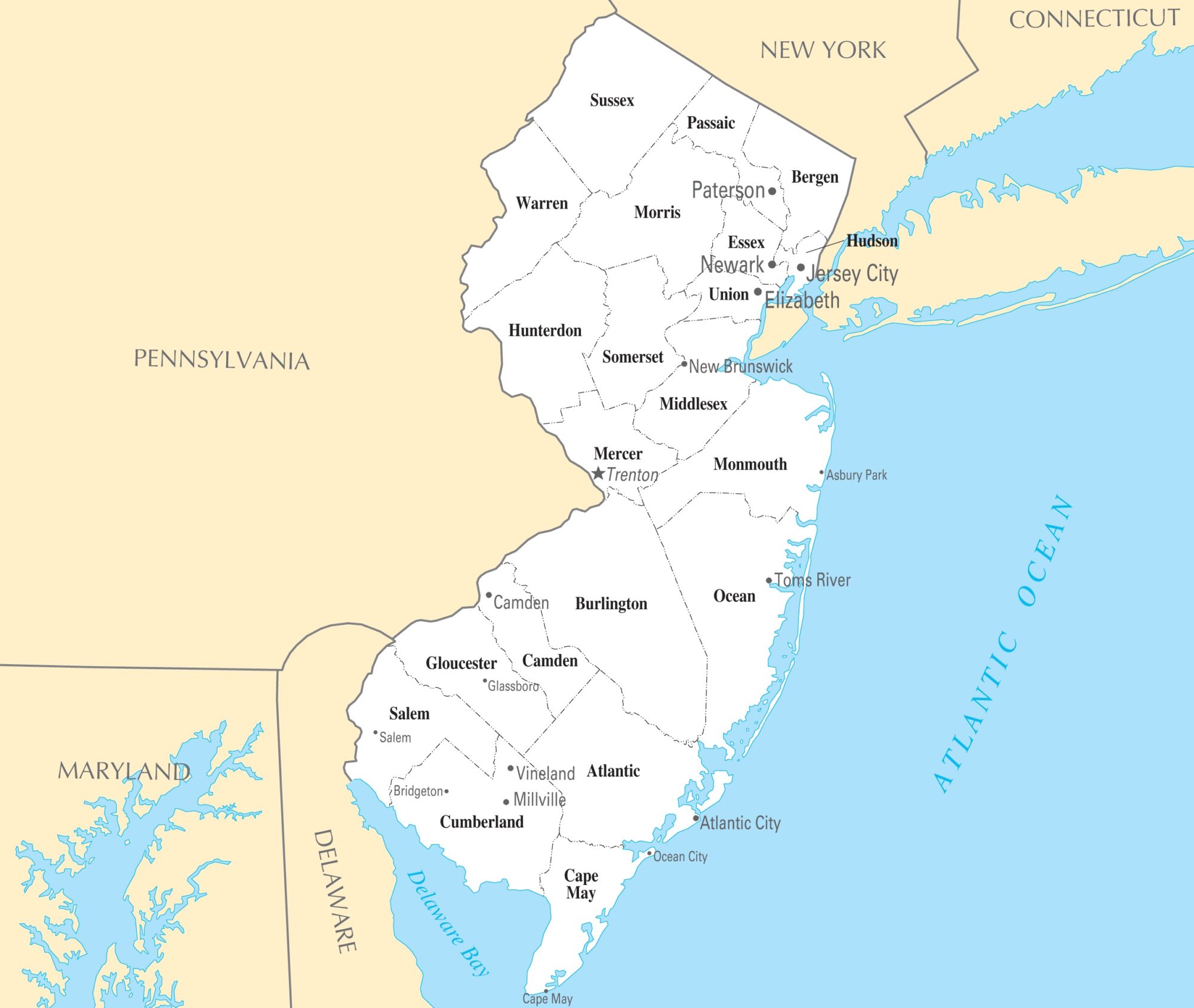
County Map of New Jersey

There are 21 counties in the state of New Jersey. These counties contain 565 municipalities, or administrative entities, 250 boroughs, 52 cities, 15 towns, 244 townships, and 4 villages. Each county is governed by a Board of Freeholders, whose records should not be overlooked. Burlington County is the largest county in New Jersey by area. Bergen County is the most populous county in the state. Bergen County, Essex County, Salem County, Burlington County are some major counties of the state.
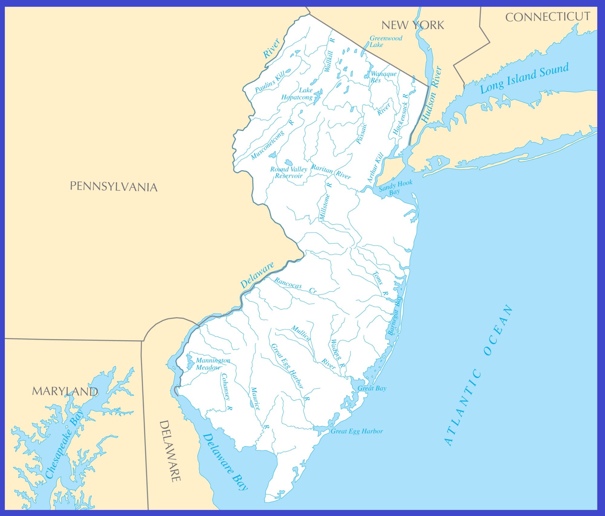
Geography Map of New Jersey

New Jersey is located in the northeastern US mainland. It is the fourth-smallest in the country by covering an area of 8,722.58 square miles. Geography Map of New Jersey shares borders with the State of New York in the north and northeast, Delaware Bay and Delaware on the southwest, and Pennsylvania in the west across the Delaware River. It also shares borders with the Atlantic Ocean On the east, southeast, and south.
The highest point in the state is “High Point” with 549.6 m (1,803 ft). It is located in the northern corner of New Jersey. The geography of New Jersey broadly divided into three regions: North Jersey, Central Jersey, and South Jersey. New Jersey’s main rivers are the Delaware River. Some important rivers of the state are Hudson, Delaware, Maurice, Mullica, Passaic, Rahway river.
In the east of the state, there is Jersey Shore with its coastal cities and towns. It is a popular vacation region, famous for its beaches, barrier island, many boardwalks with arcades, rock and roll clubs, water and amusement parks.
Transportation Map of New Jersey
![]()
The New Jersey Department of Transportation (NJDOT) maintains the Transportation Map of New Jersey. I-76, I-78, I-80, I-95, I-676, I-278, I-280, I-287, I-195, I-295, I-495 are the major interstate highways of the state. The largest and busiest airport in the state is Newark Liberty International Airport. Another major airport is Atlantic City International Airport and Trenton-Mercer Airport. New Jersey is well-connected by an extensive rail and bus service. Amtrak connects New Jersey to other states around the country.
Cities Map of New Jersey

The state capital is Trenton and the largest city is Newark (pop. 281,000). The largest cities in New Jersey are Newark (277,000), Jersey City (248,000), Paterson (147,000), Elizabeth (125,000).
Other cities and townships:
Asbury Park, Atlantic City, Bridgetown, Camden, Cape May, Freehold, Glassboro, Hammonton, Lakewood, Long Branch, Millville, Mt Holly, New Brunswick, Ocean City, Passaic, Phillipsburg, Salem, Toms River, Trenton, Vineland, and Wildwood.
New Jersey Cities Map | Large Printable High Resolution and Standard Map
New Jersey Rivers Map | Large Printable High Resolution and Standard Map