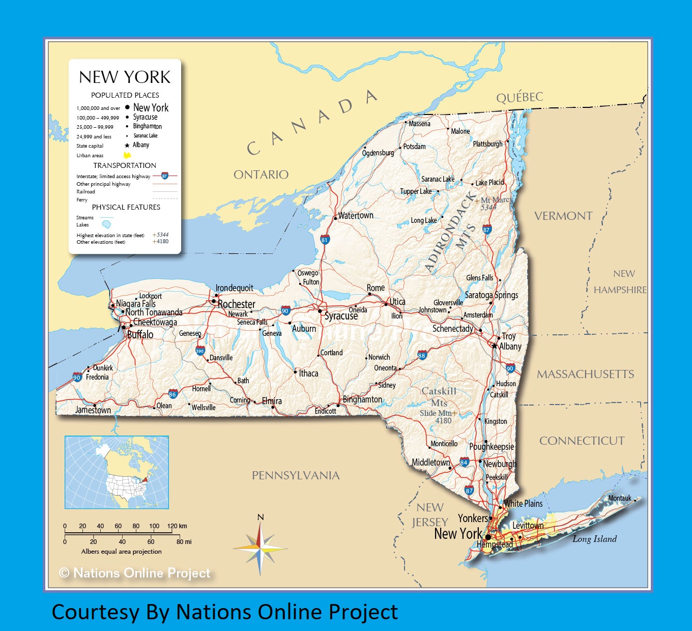
Map of New York | Political, County, Geography, Transportation, And Cities Map

Map of New York | Political, County, Geography, Transportation, And Cities Map is the Map of New York. You can also free download Map images HD Wallpapers for use desktop and laptop. Click Printable Large Map
New York is a US state in the Northeastern Region of the Country. The area of today New York was part of the original thirteen colonies of the United States. Map of New York is the 27th largest state with an area of 141,299 km² (54,556 sq mi). With more than 19 million residents, it is the 4th-most-populous state. It shares a border with two of the Great Lakes, two Canadian provinces, five U.S. states, the Atlantic Ocean, and anchored by New York City. Albany is the state capital of New York and the largest city is New York City.
Algonquian and Iroquoian-speaking Native Americans inhabited this New York Map for several hundred years. Henry Hudson, an English explorer opened the interior of this promising land to Europeans. In 1625, the Dutch began to settle what they called New Amsterdam, which was later renamed New York City by the British.
When chartered in 1664, it included a much larger area. A portion Map of New York was sold to create New Jersey in 1664, and title claims were ceded in 1682 to Delaware and Pennsylvania. New York ratified the United States’ Constitution in 1788, becoming the eleventh state to do so.
New York Facts
- Country: United States
- Admitted to the Union: July 26, 1788 (11th)
- Capital: Albany
- Motto: Excelsior (Ever upward)
- Number of Counties: 62
- Land Area: 54,555 sq mi (141,300 km2)
Political Map of New York

New York is located in the Northeastern Region of the Country. Political Map of New York bordered by New Jersey and Pennsylvania to the south and Connecticut, Massachusetts, and Vermont to the east. The state also shares international borders with the Canadian provinces of Québec and Ontario and Lake Ontario in the northwest. Albany is the state capital of New York. The state is divided into 62 counties, which are governed by the county seats.
County Map of New York

There are 62 counties in the County Map of New York. Each county is subdivided into towns and cities which incorporated under state law. Some of the major counties are Bronx County, Nassau County, New York County, Westchester County, and Suffolk County. Kings County is the most populous county with 2,504,700 people. Hamilton is the least populated county of the state. St. Lawrence County comprises 2,821 square miles is the largest county by area.
Geography Map of New York

The Geography Map of New York covers 54,555 square miles (141,300 km2) and a population of 19.3 million (2016 est). It shares a border with two of the Great Lakes, two Canadian provinces, five U.S. states, the Atlantic Ocean, and anchored by New York City. Mount Marcy in the Adirondacks, at 5,344 feet (1,629 meters) above sea level Is the highest point of New York while the Atlantic Ocean is its lowest point.
The State Geography Map is dominated by meadows, forests, rivers, farms, mountains, and lakes. The State has more than 7,600 freshwater lakes, ponds, and reservoirs, as well as portions of two of the five Great Lakes and over 70,000 miles (113,000 km). Major rivers of the state are St. Lawrence River, Black River, Hudson River, Susquehanna River, and the Delaware River.
Transportation Map of New York
![]()
Transportation Map of New York is one of the most extensive and oldest transportation infrastructures in the country. The New York State Department of Transportation (NYSDOT) is responsible for the operation of highways, railroads, waterways, and aviation facilities within New York State.
There are 31 Interstate Highways, 9 main routes, and 22 auxiliary routes—that exist in the U.S. state of New York. The interstate highways are I-78, I-81, I-84, I-86, I-87, I-88, I-90, I-95, I-99, I-278, I-478, I-678, I-878, I-481, I-781, I-684, I-287, I-587, I-687, I-787, I-190, I-290, I-390, I-490, I-590, I-690, I-790, I-890, I-990, I-295, I-495, I-695, I-895.
The largest airports in the state are New York City’s John F. Kennedy International Airport, LaGuardia Airport, and Buffalo Niagara International Airport in Buffalo. New York presently only boasts the Buffalo Metro Rail, which is arguably a light rail system
Cities Map of New York

Albany is the state capital of New York. The largest city and the most populous city in the United States is New York City. The city is an international hub for trade, finance, the arts, and culture. The largest metro area is the New York City Metropolitan Area with a population of 22.2 million.
The 10 Biggest Cities In New York State
| Rank | City | County | Population (2010 Census) | Date Of Incorporation |
|---|---|---|---|---|
| 1 | New York | Bronx, Kings, New York, Queens, and Richmond | 81,75,133 | 1653 |
| 2 | Buffalo | Erie | 2,61,310 | 1832 |
| 3 | Rochester | Monroe | 2,10,565 | 1834 |
| 4 | Yonkers | Westchester | 1,95,976 | 1872 |
| 5 | Syracuse | Onondaga | 1,45,170 | 1848 |
| 6 | Albany | Albany | 97,856 | 1686 |
| 7 | New Rochelle | Westchester | 77,062 | 1889 |
| 8 | Mount Vernon | Westchester | 67,292 | 1892 |
| 9 | Schenectady | Schenectady | 66,135 | 1798 |
| 10 | Utica | Oneida | 62,235 | 1832 |
New York Cities Map | Large Printable High Resolution and Standard Map
New York Transportation and physical map large printable