Map of Europe | Printable Large Attractive HD Map of Europe

Map of Europe is the 6th largest Continent Comprising 10,360,000 sq km including adjacent islands (1992 est. pop. 512,000,000). It is located entirely in the Northern Hemisphere and mostly in the Eastern Hemisphere. Europe is actually a vast peninsula of the great Eurasian landmass.
Europe is separated from Asia by the Black Sea, the Bosporus, the Sea of Marmara, and the Dardanelles in the south, By the Urals and the Ural River in the east; by the Caspian Sea and the Caucasus in the southeast. The Strait of Gibraltar and the Mediterranean Sea separate it from Africa.
Map of Europe Facts
- Population: about 740 million. That sounds a lot but there is five times that number of people living today in Asia!
- Land Area: 9,908,600 square kilometers (or 3,825,730 square miles) – it’s about a third of the size of Africa.
- Countries: 46 countries (of which 27 are members of the European Union or EU).
- Highest Peak: Mount Elbrus in Russia stands at 5,643 meters above sea level.
- Largest Lake: Lake Ladoga in northwestern Russia has an area of 17,700 square kilometers (6,800 square miles).
- Longest River: The Volga River in Russia is 3,530 kilometers (2,193 miles) long.
- Smallest Country (by land area and population): Vatican City is a tiny country within the Italian city of Rome. The Pope, the leader of the worldwide Catholic Church, lives here along with its 800 other citizens.
- Biggest Country (by land area): the Russian Federation is the biggest country by land area, not just in Europe but across the whole world!
- Languages: there are more than 200 different languages spoken in Europe. The EU recognizes 23 languages that are in common use amongst its member countries, where two of every three Europeans live.
HD Map of Europe

Several Region of Europe
Eastern Europe: Belarus, Bulgaria, Czech Republic, Hungary, Poland, Moldova, Romania, Russia. Slovakia, Ukraine
Northern Europe: Aland Islands, Denmark, Estonia, Faroe Islands, Finland, Guernsey, Iceland, Ireland, Isle of Man, Jersey, Latvia, Lithuania, Norway, Sark, Svalbard, and Jan Mayen, Sweden, United Kingdom (Great Britain and Northern Ireland)
Southern Europe: Albania, Andorra, Bosnia and Herzegovina, Croatia, Gibraltar, Greece, Italy, Republic of Macedonia. Malta, Montenegro, Portugal, San Marino, Serbia, Slovenia, Spain, Vatican City
Western Europe: Austria, Belgium, France, Germany, Liechtenstein, Luxembourg, Monaco, Netherlands, Switzerland
Map of Europe | Printable Large Attractive HD Map of Europe. You can also free download Map images HD Wallpapers for use desktop and laptop.
Printable Large Map of Europe
The Printable Blank Map of Europe on this post clearly defines the geographical and political boundaries of the continent. The political boundaries of various countries in the continent are also marked on the map.
HD Map of Europe
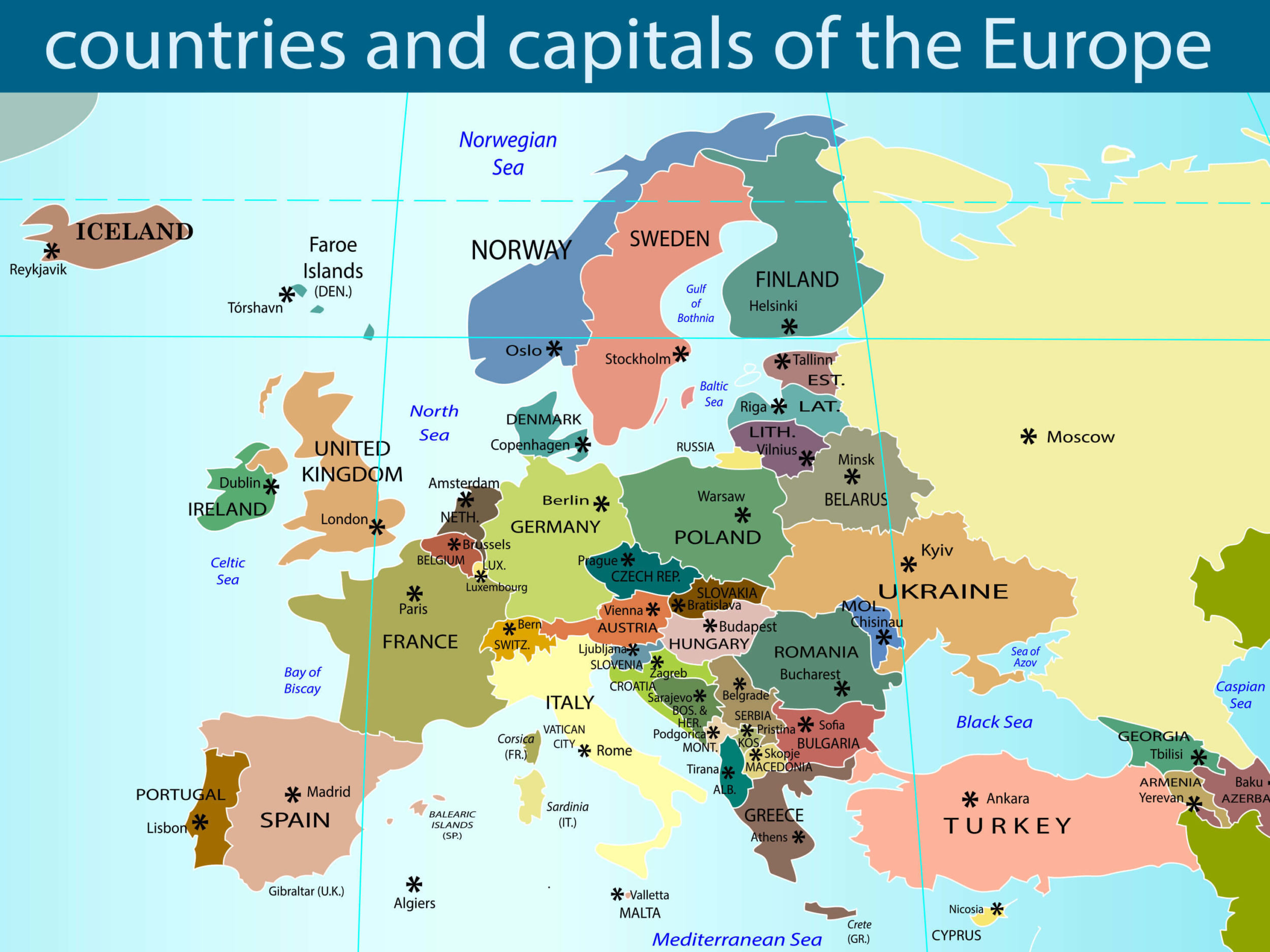
The HD Map of Europe clearly defines the geographical and political boundaries of the continent. The boundaries that demarcate one nation from the other in Europe are also marked on the map.
Political Large Map of Europe
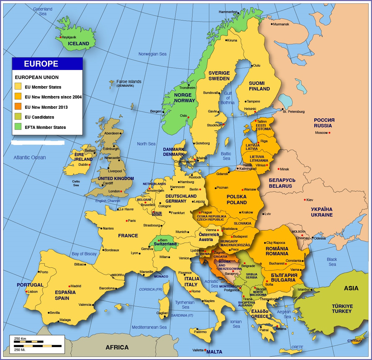
Europe is connected by land to Asia on its east, while oceans and seas lie to its southeast, southwest, west, and north as shown in the map of Europe. The continent features a 24,000 mile-long coastline. Europe features some of the oldest mountains on the planet.
Map of Europe | Large Political Map of Europe
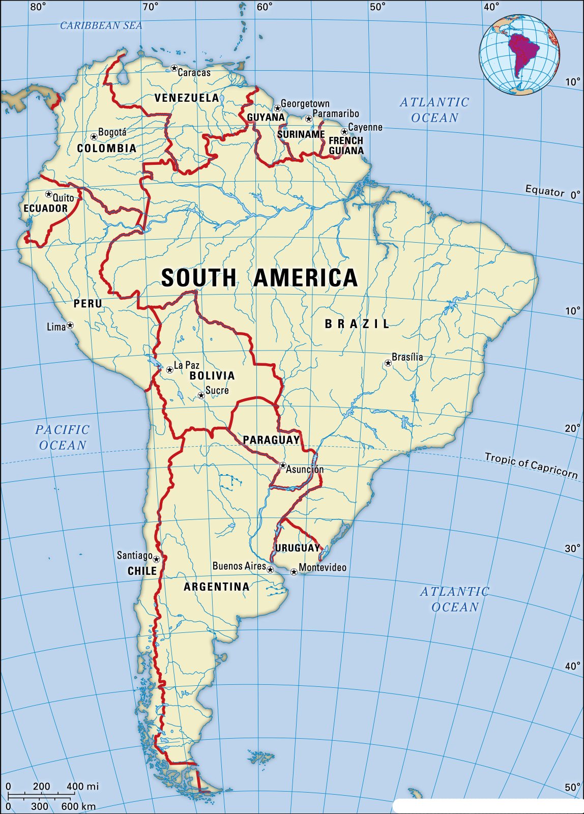
Map of South America | Printable Large Attractive HD Map of South America