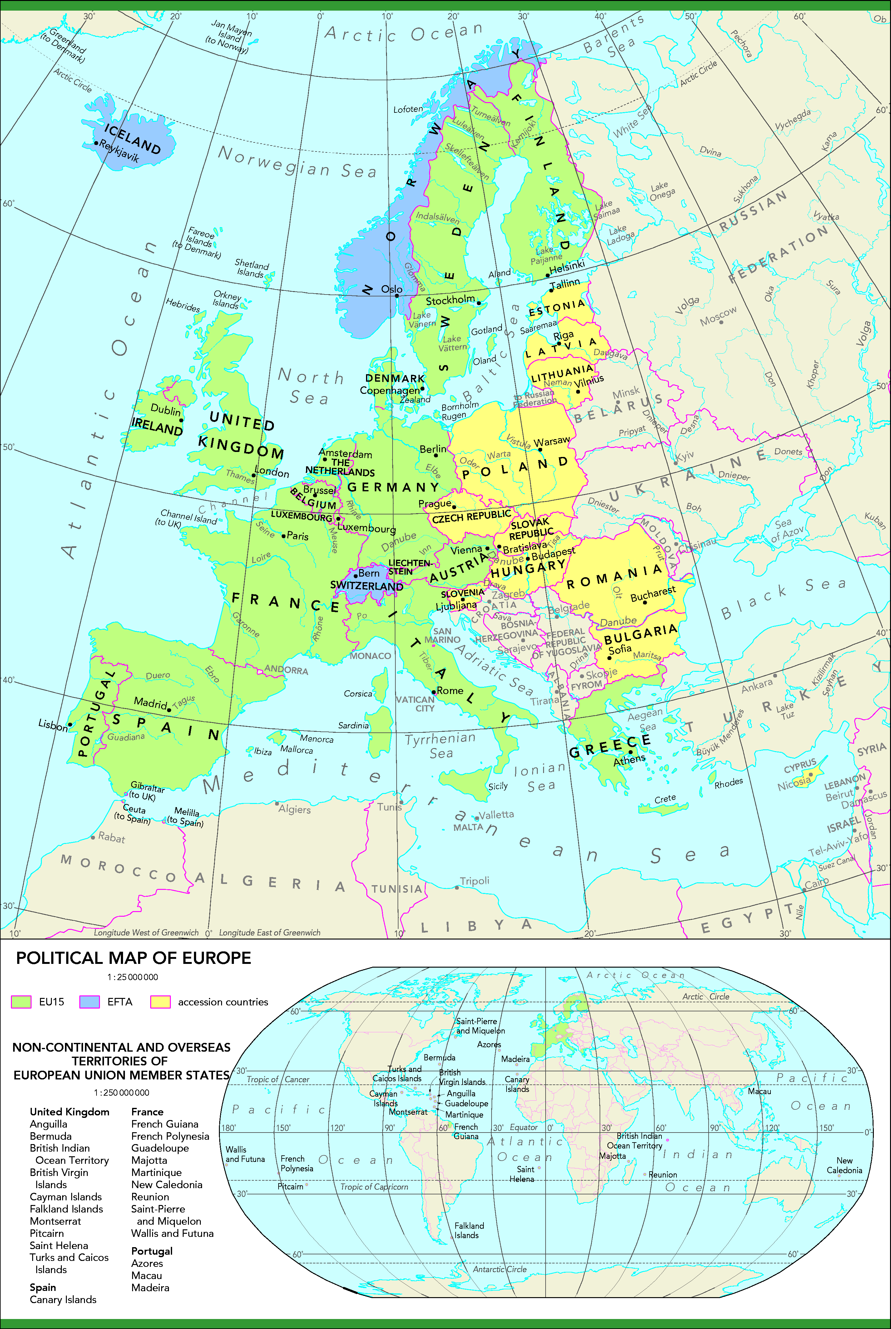
Map of Europe | Large Political Map of Europe

The Political Map of Europe shows the countries that are located on the continent and there political boundaries of each nation and makes it easy to distinguish one from the other.
Europe is the 6th largest Continent Comprising 10,360,000 sq km including adjacent islands (1992 est. pop. 512,000,000). It is located entirely in the Northern Hemisphere and mostly in the Eastern Hemisphere. Europe is actually a vast peninsula of the great Eurasian landmass.
Europe is separated from Asia by the Black Sea, the Bosporus, the Sea of Marmara, and the Dardanelles in the south, By the Urals and the Ural River in the east; by the Caspian Sea and the Caucasus in the southeast. The Strait of Gibraltar and the Mediterranean Sea separate it from Africa. Europe is washed in the north by the Arctic Ocean, and in the west by the Atlantic Ocean, with which the North Sea and the Baltic Sea are connected.
Both Russia and Turkey have territories within Europe and have some of their areas are located in Asia as well – further blurring the separation between the two in the map of Europe. As of 2016, the population of Europe stood at 741.4 million.
There are 44 countries in Europe today, according to the United Nations. The full list is shown in the table below, with the current population and subregion (based on the United Nations official statistics).

Countries With Population
| # |
Country |
Population (2020) |
| 1 | Russia | 145,934,462 |
| 2 | Germany | 83,783,942 |
| 3 | United Kingdom | 67,886,011 |
| 4 | France | 65,273,511 |
| 5 | Italy | 60,461,826 |
| 6 | Spain | 46,754,778 |
| 7 | Ukraine | 43,733,762 |
| 8 | Poland | 37,846,611 |
| 9 | Romania | 19,237,691 |
| 10 | Netherlands | 17,134,872 |
| 11 | Belgium | 11,589,623 |
| 12 | Czech Republic (Czechia) | 10,708,981 |
| 13 | Greece | 10,423,054 |
| 14 | Portugal | 10,196,709 |
| 15 | Sweden | 10,099,265 |
| 16 | Hungary | 9,660,351 |
| 17 | Belarus | 9,449,323 |
| 18 | Austria | 9,006,398 |
| 19 | Serbia | 8,737,371 |
| 20 | Switzerland | 8,654,622 |
| 21 | Bulgaria | 6,948,445 |
| 22 | Denmark | 5,792,202 |
| 23 | Finland | 5,540,720 |
| 24 | Slovakia | 5,459,642 |
| 25 | Norway | 5,421,241 |
| 26 | Ireland | 4,937,786 |
| 27 | Croatia | 4,105,267 |
| 28 | Moldova | 4,033,963 |
| 29 | Bosnia and Herzegovina | 3,280,819 |
| 30 | Albania | 2,877,797 |
| 31 | Lithuania | 2,722,289 |
| 32 | North Macedonia | 2,083,374 |
| 33 | Slovenia | 2,078,938 |
| 34 | Latvia | 1,886,198 |
| 35 | Estonia | 1,326,535 |
| 36 | Montenegro | 628,066 |
| 37 | Luxembourg | 625,978 |
| 38 | Malta | 441,543 |
| 39 | Iceland | 341,243 |
| 40 | Andorra | 77,265 |
| 41 | Monaco | 39,242 |
| 42 | Liechtenstein | 38,128 |
| 43 | San Marino | 33,931 |
| 44 | Holy See | 801 |
Countries and Capital Map of Europe

Europe Several Regions
Eastern Europe: Belarus, Bulgaria, Czech Republic, Hungary, Poland, Moldova, Romania, Russia. Slovakia, Ukraine
Northern Europe: Aland Islands, Denmark, Estonia, Faroe Islands, Finland, Guernsey, Iceland, Ireland, Isle of Man, Jersey, Latvia, Lithuania, Norway, Sark, Svalbard, and Jan Mayen, Sweden, United Kingdom (Great Britain and Northern Ireland)
Southern Europe: Albania, Andorra, Bosnia and Herzegovina, Croatia, Gibraltar, Greece, Italy, Republic of Macedonia. Malta, Montenegro, Portugal, San Marino, Serbia, Slovenia, Spain, Vatican City
Western Europe: Austria, Belgium, France, Germany, Liechtenstein, Luxembourg, Monaco, Netherlands, Switzerland
Map of Europe | Large Political Map of Europe. You can also free download Map images HD Wallpapers for use desktop and laptop.
Physical Map
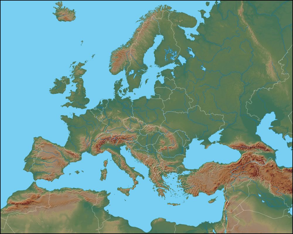
The Physical Map reveals the physical landscape of Europe. There are several important mountain ranges. The Pyrenees Mountains are the boundary between Spain and France. The Alps separate Italy from countries to the north. The Massif Central is in the southwest of France. In Greece are the Pindus Mountains and the Rhodope Mountains.
The Caucasus Mountains separate Georgia and Azerbaijan from Russia. Eastern Europe has the Carpathian Mountains and the Transylvanian Alps. The Ural Mountains trend north-south through Russia and most physical geographers consider them to be the dividing range between Europe and Asia. Major bodies of water include the Caspian Sea, Black Sea, Aegean Sea, Ionian Sea, Adriatic Sea, Mediterranean Sea, Balearic Sea, Alboran Sea, Bay of Biscay, Celtic Sea, English Channel, North Sea, Norwegian Sea, Baltic Sea, Barents Sea, White Sea, and the Gulf of Bothnia.
Geography of Europe
Europe is connected by land to Asia on its east, while oceans and seas lie to its southeast, southwest, west, and north as shown in the map of Europe. The continent features a 24,000 mile-long coastline. Europe features some of the oldest mountains on the planet. The Alps were formed when the continent of Africa moved north and collided with Europe. Europe and Asia, are together referred to as 'Eurasia.'
Economy and Industry

Germany and France shown in the map of Europe continue to drive the European economy. The United Kingdom has opted to exit the European Union but will continue to remain an active participant in the European economy. Russia's economy is mainly driven by oil refining and defense manufacturing.
Switzerland continues to be the focal country for banking and investment, followed by the UK, Germany, and France. With Brexit looming, London’s status as a financial hub is now being challenged by Frankfurt and Paris. In the manufacturing sector, Germany, France, Italy, and Sweden lead the way in their respective areas of dominance. France, UK, Germany, and Russia remain dependent on a growing defense industry.
Reference:
Map of Europe | Printable Large Attractive HD Map of Europe
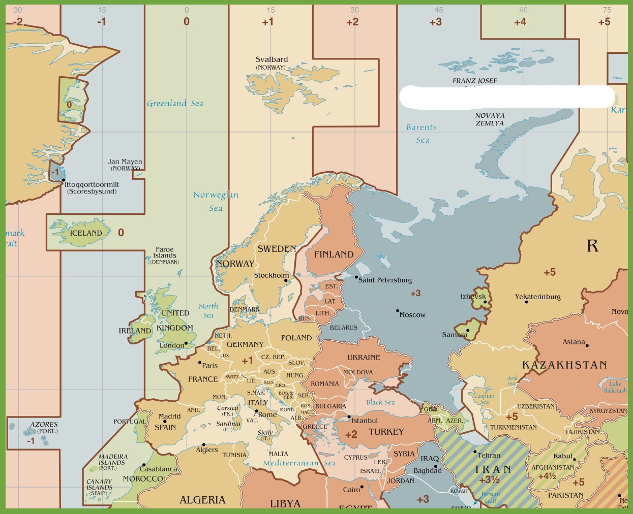
Time Zone Map of Europe | HD Time Zone Map