National Capital, States Capital, Major Cities, Roads And Rivers Map of the USA

National Capital, States Capital, Major Cities, Roads And Rivers Map of the USA is the Map of United States of America. You can also free download United States of America Map images HD Wallpapers for use desktop and laptop. Click Printable Large Map
The Capital City of the United States of America is Washington, D.C., and can be referred to formally as the District of Columbia. The city had a population of 6,131,977 and an approximate size of 68.34 square miles. According To The National Capital Map of the USA, Washington, D.C Is Located on the East Coast of the United States and it is bound by the states of Virginia and Maryland.
The Capital City was founded after the American Revolution and named after the Founding Father and first President of the United States of America, General George Washington.
Cities Map of the USA

States Capital Map of USA
This is a list of the 50 current state capitals of the United States.
| Capital Cities | States |
|---|---|
| Montgomery | Alabama |
| Juneau | Alaska |
| Phoenix | Arizona |
| Little Rock | Arkansas |
| Sacramento | California |
| Denver | Colorado |
| Hartford | Connecticut |
| Dover | Delaware |
| Tallahassee | Florida |
| Atlanta | Georgia |
| Honolulu | Hawaii |
| Boise | Idaho |
| Springfield | Illinois |
| Indianapolis | Indiana |
| Des Moines | Iowa |
| Topeka | Kansas |
| Frankfort | Kentucky |
| Baton Rouge | Louisiana |
| Augusta | Maine |
| Annapolis | Maryland |
| Boston | Massachusetts |
| Lansing | Michigan |
| St. Paul | Minnesota |
| Jackson | Mississippi |
| Jefferson City | Missouri |
| Helena | Montana |
| Lincoln | Nebraska |
| Carson City | Nevada |
| Concord | New Hampshire |
| Trenton | New Jersey |
| Santa Fe | New Mexico |
| Albany | New York |
| Raleigh | North Carolina |
| Bismarck | North Dakota |
| Columbus | Ohio |
| Oklahoma City | Oklahoma |
| Salem | Oregon |
| Harrisburg | Pennsylvania |
| Providence | Rhode Island |
| Columbia | South Carolina |
| Pierre | South Dakota |
| Nashville | Tennessee |
| Austin | Texas |
| Salt Lake City | Utah |
| Montpelier | Vermont |
| Richmond | Virginia |
| Olympia | Washington |
| Charleston | West Virginia |
| Madison | Wisconsin |
| Cheyenne | Wyoming |
✅Map of USA With Capitals
Each of the U.S. states and the five major territories of the United States has a capital city. Not every capital is the cultural and economic center or the most populous city of its state, but every capital is the seat of state government.
Road Map of USA
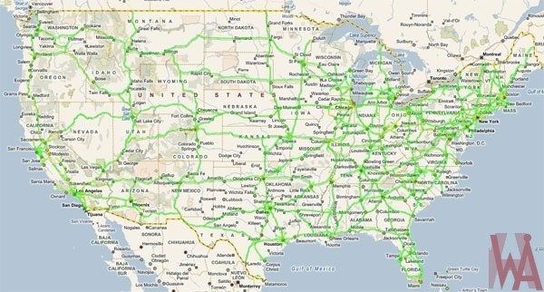
The USA has The longest Road network in the world. The US has a road stretch of more than 4 million miles (6,586,610 km), as per the 2012 CIA Factbook. The USA also has the world's largest railway network which covers over 180,000 miles (293,564 km). It also has more airports than any other country in the world - 3,513 airports (2013 estimate). The Road Map of USA comprises the Interstate Highway System as well as other roads that connect the rails, railway stations, ports, truck terminals, major airports, etc, of the country.
River Map of USA
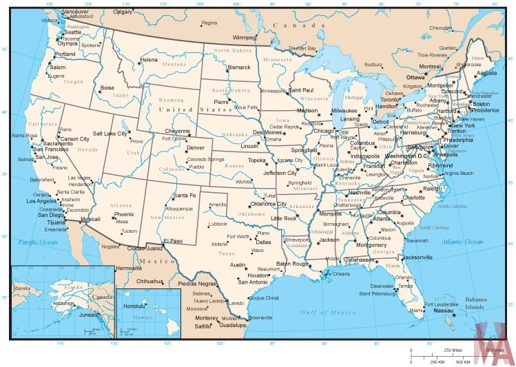
The Us Geography Map Shows That The Country has over 250,000 rivers. Those Rivers provide drinking water, irrigation water, transportation, electrical power, drainage, food, and recreation. According to US Major Rivers Map, The longest river in the USA is the Missouri River; it is a tributary of the Mississippi River and is 2,540 miles long. But the biggest in terms of water volume is the deeper Mississippi River.
Reference:


