Map of Arizona | Political, Physical, Geographical, Transportation, And Cities Map

Map of Arizona | Political, Physical, Geographical, Transportation, And Cities Map is the Map of Arizona. You can also free download Map images HD Wallpapers for use desktop and laptop. Click Printable Large Map
The Map of Arizona is located in the southwestern region of the US. It is the 6th largest state and the 14th most populous state of the United States. Arizona is the last of the contiguous US states to be admitted to the Union. It achieve statehood on February 14, 1912. Arizona is famous for the Grand Canyon and copper all over the world.
Spain colonized the area in 1598 and Arizona was part of New Spain until 1821. In 1846 United States forces invaded and occupied the region of Arizona. The Arizona region was known as Nuevo México (New Mexico) At that time. The US pays Mexico $10 million for 76,845 km² (29,670 sq mi) of Mexican territory that becomes part of Arizona In the Gadsden Purchase of 1854.
The United States government-administered the present Arizona state as a part of the Territory of New Mexico. The US government declared Arizona as a new U.S. Territory in Washington, D.C., on February 24, 1863.
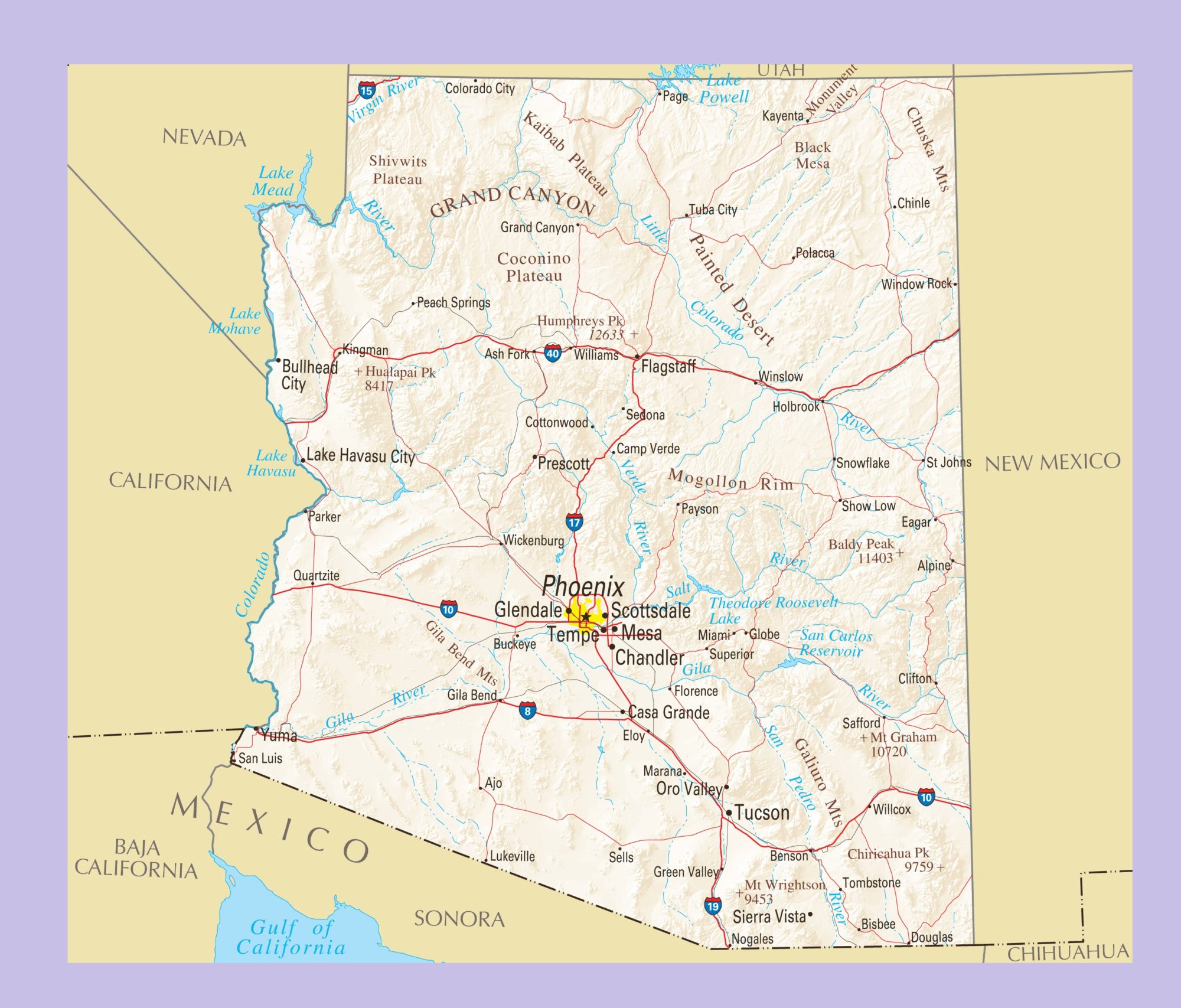
Political Map of Arizona

The Political Map of Arizona shares its border with the Four Corners region with Utah, Colorado, and New Mexico. its other neighboring states are Nevada and California to the west and the Mexican states of Sonora and Baja California to the south and southwest. At the Four Corners’ Point, Arizona meets Colorado in the extreme the northeast.
Phoenix is the capital of Arizona and it is also the largest city of the state. Arizona occupies an area of 295,234 km² (113,990 sq mi). Arizona consists of 15 counties. Other major cities in the Phoenix metro area include Mesa, Chandler, Glendale, Peoria, Buckeye, Sun City, Sun City West, Fountain Hills, Surprise, Gilbert, El Mirage, Avondale, Tempe, Tolleson, and Scottsdale.
Physical Map of Arizona

Arizona is located in the southwestern region of the US. It is the 6th largest state and the 14th most populous state of the United States. Physical Map of Arizona is the 6th largest state Map with an area of 295,234 km² (113,990 sq mi). Arizona is famous for its desert Basin and Range region in the state’s southern portions. This region is rich in a landscape of xerophyte plants such as the cactus.
The Grand Canyon is a colorful, deep, steep-sided gorge, carved by the Colorado River. It is one of the Seven Natural Wonders of the World. Monument Valley on the On the Arizona-Utah state line is well-known for sandstone buttes, the tallest reaching 300 m (1,000 ft) above the valley floor.
Geography Map of Arizona

Geography Map of Arizona covers an area of 113,990 square miles. The state shares its borders with the US states of New Mexico, Nevada, Utah, California, and one point common with Colorado. its other neighboring states are Nevada and California to the west. The Mexican states of Sonora and Baja California to the south and southwest. At the Four Corners’ Point, Arizona meets Colorado in the extreme the northeast.
Arizona is famous for its desert Basin and Range region in the state’s southern portions. This region is rich in a landscape of xerophyte plants such as the cactus. Humphreys Peak is the highest natural point in the state with 3,852 m (12,637 ft).
Major Rivers of Arizona: The Colorado River, The Little Colorado River, Gila River, Salt River, Verde River, Santa Cruz River Etc.
The Grand Canyon is one of the most popular tourist spots in Arizona. Its spectacular landscape is famous in the world. UNESCO Declared Grand Canyon as a World Heritage Site. It is one of America’s best-known natural landmarks.
Transportation Map of Arizona
![]()
Transportation Map of Arizona features highway and airport. Phoenix Sky Harbor International Airport is the major and 7th busiest airport in the world. Another major airport is Tucson International Airport. A rail system was completed in December 2008. It is called Valley Metro Rail and connects Central Phoenix with the nearby cities of Mesa and Tempe.
Bus services are provided by Greyhound lines. It serves Phoenix, Tucson, Flagstaff, Yuma, and certain other areas. Main Interstate routes include I-17, and I-19 traveling north-south, I-8, I-10, and I-40.
Cities Map of Arizona

Phoenix is the capital of Arizona and it is also the largest city of the state. Arizona occupies an area of 295,234 km² (113,990 sq mi).
Other Major Cities:
Mesa, Chandler, Glendale, Peoria, Buckeye, Sun City, Sun City West, Fountain Hills, Surprise, Gilbert, El Mirage, Avondale, Tempe, Tolleson, and Scottsdale, Apache Junction, Bullhead City, Casa Grande, Chandler, Douglas, Flagstaff, Florence, Fountain Hills, Gilbert, Glendale, Goodyear, Green Valley, Kingman, Lake Havasu City, Mesa, Nogales, Oro Valley, Payson, Peoria, Phoenix, Prescott, Prescott Valley, San Luis, Scottsdale, Sierra Vista, Sun City, Sun City West, Surprise, Tempe, Tucson, Winslow, and Yuma.
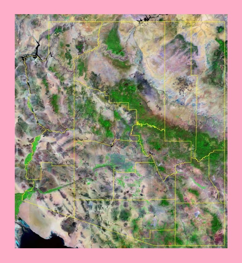
Arizona Satellite Map | Large Printable and Standard Map
Arizona Political Map | Large Printable and Standard Map 2