Map of Colorado | Political, Physical, Geographical, Transportation, And Cities Map

Map of Colorado | Political, Physical, Geographical, Transportation, And Cities Map is the Map of Colorado. You can also free download Map images HD Wallpapers for use desktop and laptop. Click Printable Large Map
Colorado is one of the 50 US states located in the western United States. It is the 8th largest and 21st most populous state. The Territory of Colorado was organized on February 28, 1861. It joined the union on August 1, 1876, as the 38th state. Map of Colorado covers an area of 104,094 square miles and the estimated population is 5.77 million.
The State is famous for its vivid landscape of mountains, forests, high plains, mesas, canyons, plateaus, rivers, and desert lands. Colorado shares its border with Wyoming to the north, Nebraska to the northeast, Kansas to the east, Oklahoma to the southeast, New Mexico to the south, Utah to the west, and Arizona to the southwest, at the Four Corners of Colorado Map. The capital is Denver. It is also the largest city in Colorado.
The area was first inhabited by various Native American tribes more than 13,000 years ago. The region was acquired by the Union in the Louisiana purchase of 1803 from the French. The land achieved US statehood on August 1, 1876. Colorado is called the “Centennial State” because it became a state one century after the signing of the United States Declaration of Independence.
Political Map of Colorado

Political Map of Colorado shares its border with Wyoming to the north, Nebraska to the northeast. It also shares a border with Kansas to the east, Oklahoma to the southeast, New Mexico to the south, Utah to the west, and Arizona to the southwest, at the Four Corners. The Colorado Political Map shows Colorado with boundaries, the state capital Denver, major cities, and populated places.
The Government of Colorado is Consist of 3 Branches:
1. Executive
2. Legislative
3. Judicial
These branches consist of the state governor’s office and a state court system. The Colorado Constitution delineates the structure and function of the state government. Colorado has four seats in the U.S. House of Representatives and two seats in the U.S. Senate.
Physical Map of Colorado

Colorado is located in the western United States. It is the 8th largest and 21st most populous state. Physical Map of Colorado covers an area of 104,094 square miles and the estimated population is 5.77 million. It is classified as one of the Mountain states, although only about half of its area lies in the Rocky Mountains.
The map of Colorado state covers the southern Rocky Mountains. The westernmost part of the great plains as well as parts of the Colorado plateau. The State is famous for its vivid landscape of mountains, forests, high plains, mesas, canyons, plateaus, rivers, and desert lands.
Geography Map of Colorado
Colorado is a landlocked state and bordered by Wyoming, Kansas, Nebraska, Oklahoma, New Mexico, Utah, and Arizona. Geography Map of Colorado is known for its diverse geography. It includes alpine mountains, high plains, deserts with huge sand dunes, and deep canyons. There are 53 summits of the Rocky mountain ranges in Colorado. The highest point in Colorado is Mount Elbert at 4401 m (14,440 ft). The semiarid Great Plains in the east are the agricultural heartland of Colorado.
Colorado has one World Heritage Site in Montezuma County known as Mesa Verde plateau at an altitude of more than 2,600 m. The Cliff Palace in Mesa Verde National Park is the largest cliff dwelling in North America. The complex was built between the 6th and 12th centuries by ancient Pueblo people (Anasazi) on the Mesa Verde plateau.
Colorado’s Four Geographic Regions:
- The Great Plains
- The Rocky Mountains
- The Colorado Plateau
- The Intermontane Basin
Transportation Map of Colorado
![]()
The primary mode of transportation of Colorado’s (in terms of passengers) is its highway system. Interstate 25 (I-25) is the primary north-south highway in the state. It connects Colorado with Pueblo, Colorado Springs, Denver, and Fort Collins, and extends north to Wyoming and south to New Mexico. I-70 is another primary highway to connect the east-west corridor. It connects Grand Junction and the mountain communities with Denver then enters Utah and Kansas. Transportation Map of Colorado
Denver International Airport(DIA) is the fifth-busiest domestic airport in the US. It handles most of the air traffic between Chicago and the Pacific coast. It handles the largest volume of commercial air traffic in Colorado.
- The California Zephyr
- Southwest Chief
Cities Map of Colorado

The capital of Colorado is Denver. It is also the largest city in Colorado. The major cities of Colorado are Denver, Colorado Springs, Boulder, Fort Collins, and Aurora.
Other cities and towns in Colorado:
Akron, Alamosa, Antonito, Arvada, Aspen, Black Forest, Brighton, Broomfield, Brush, Burlington, Byers, Canon City, Castle Rock, Cheyenne Wells, Cortez, Craig, Cripple Creek, Del Norte, Delta, Dinasaur, Durango, Eads, Englewood, Estes Park, Fairplay, Florence, Fort, Fruita, Glenwood Springs, Granby, Grand Junction, Greeley, Gunnison, Holyoke, Idaho Springs, Julesburg, La Junta,
Lakewood, Lamar, Las Animas, Last Chance, Leadville, Limon, Littleton, Longmont, Loveland, Meeker, Monte Vista, Montrose, Morgan, Orchard City, Ordway, Ouray, Pagosa Springs, Pueblo, Rangely, Rifle, Rocky Ford, Saguache, Salida, Security, Silverton, Springfield, Springs, Steamboat, Sterling, Telluride, Trinidad, Vail, Walden, Walsenburg, and Wray.
Colorado Blank Outline Map | Large Printable and Standard Map

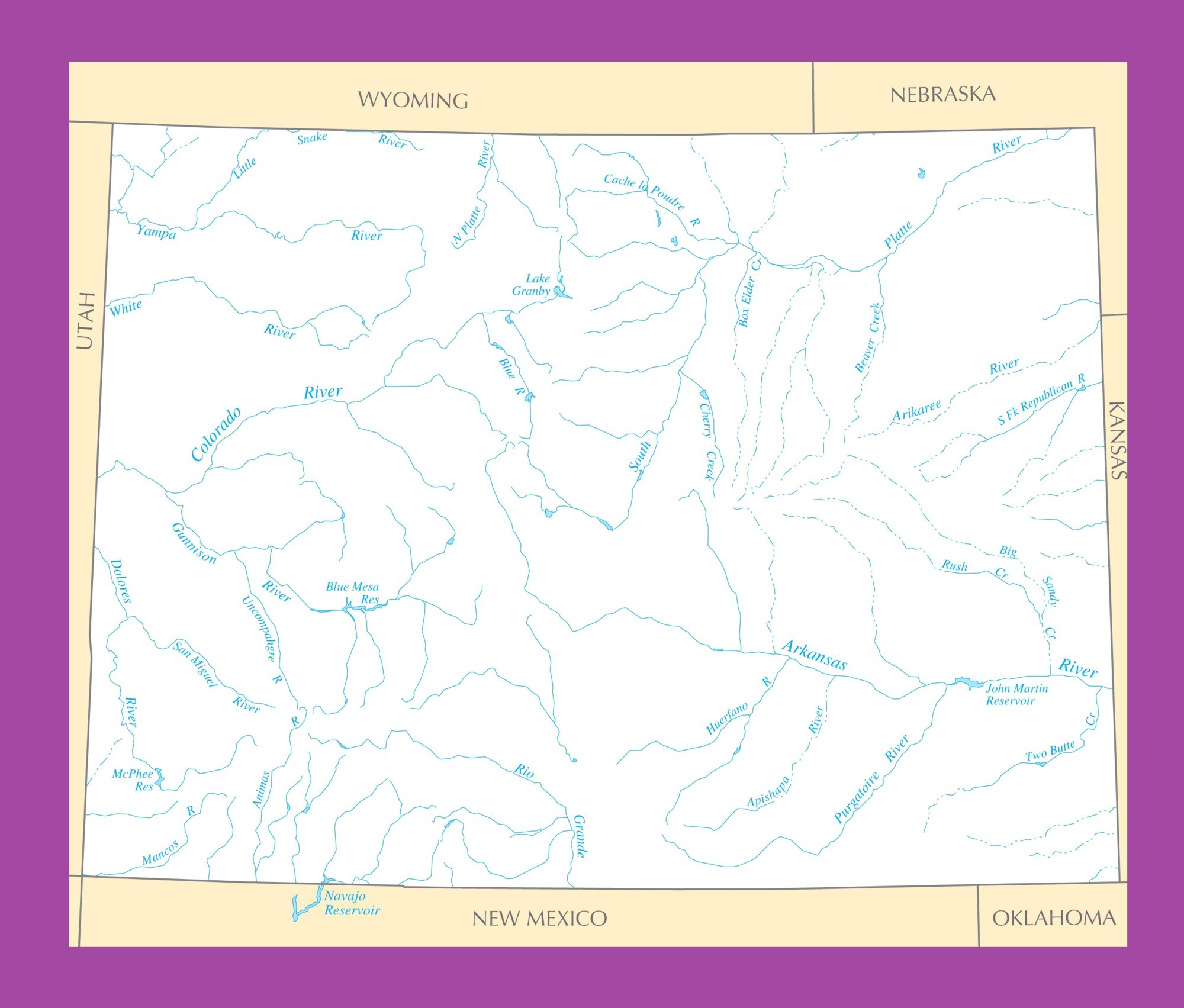
Colorado River Map | Large Printable and Standard Map