Map of Alabama | Political, Physical, Geographical, And Cities Map

Map of Alabama | Political, Physical, Geographical, And Cities Map is the Map of Alabama. You can also free download Map images HD Wallpapers for use desktop and laptop. Click Printable Large Map
Alabama is one of the 50 states in the US. It is the 30th largest state by area and the 24th-most populous of the U.S. states. Map of Alabama Cover 1,500 miles (2,400 km) of inland waterways which has among the most of any state. Alabama located in the southeastern region of the United States Map.
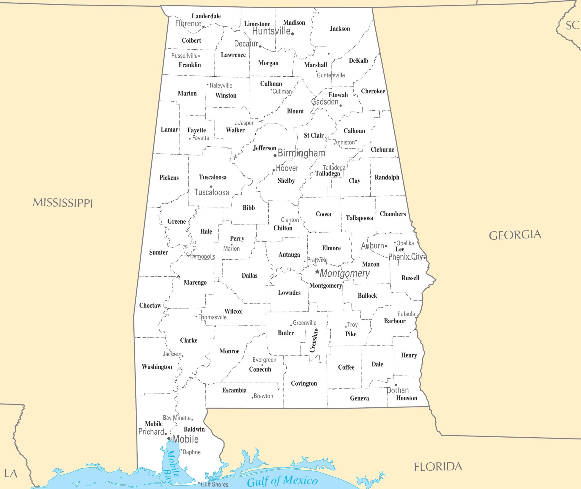
Nicknamed ‘The Yellowhammer State’, Alabama is divided into 67 counties. Birmingham is the most populous city in the state while Mobile is the oldest.
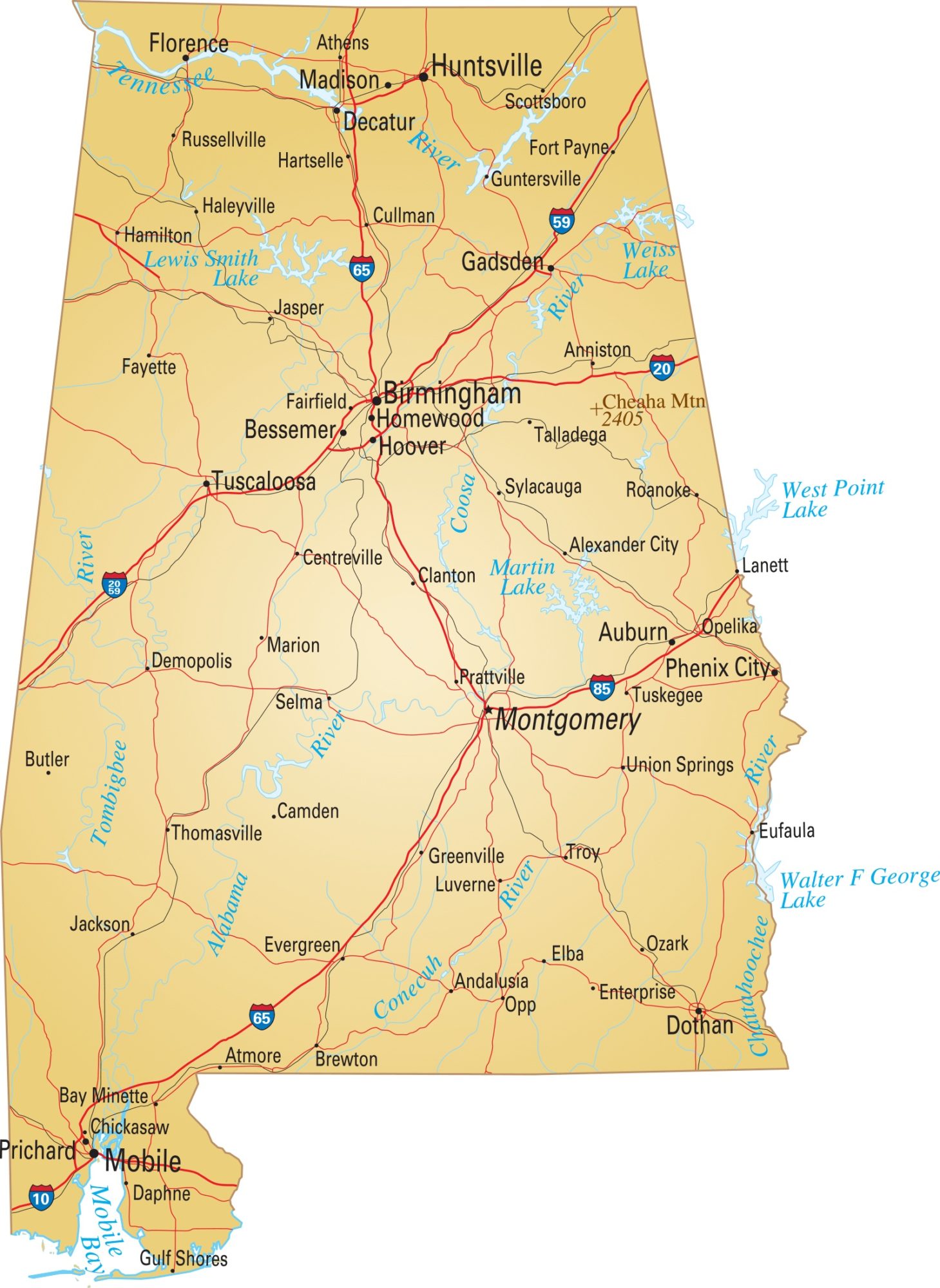
The Political Map of Alabama is bordered by Tennessee to the north, Georgia to the east, Florida and the Gulf of Mexico to the south, and Mississippi to the west. The State Capital of Alabama is Montgomery. Some of the major cities shown in this Map of Alabama is Birmingham, Mobile, and Huntsville.
Political Map of Alabama

Alabama Political Map is divided into 7 congressional districts. Each congressional district is represented by a member of the United States House of Representatives. The delegation has a total of 7 members, including 6 Republicans and 1 Democrat. Alabama is bordered by Tennessee to the north, Georgia to the east, Florida and the Gulf of Mexico to the south, and Mississippi to the west. The State Capital of Alabama is Montgomery.
Physical Map Of Alabama

Alabama is located in the southeastern United States between Mississippi and Georgia states. It shares a border with Tennessee to the north, Georgia to the east, Florida and the Gulf of Mexico to the south, and Mississippi to the west. Alabama Physical Map occupies the area of 135,767 km² (52,420 sq mi). Alabama is six times larger than New Jersey, but it would fit into Texas about five times.
Alabama’s physiographic sections offer five major regions. Three physiographic sections are located in the Appalachian Highlands region. These are the Piedmont Upland section, Tennessee Valley and Ridge section, and finally the Cumberland. The other two sections are located in the state are the Highland Rim section and the East Gulf Coastal Plain section.
Geographical Map of Alabama

Alabama is the 13th largest state in the United States with an area of 52,419 square miles (135,760 km2). 3.2% of the area is water, making the second-largest inland waterway system in the United States. About three-fifths of the land area is a gentle plain with a general descent towards the Mississippi River and the Gulf of Mexico.
The North Alabama Geographical Map region is mostly mountainous, with the Tennessee River cutting a large valley and creating numerous creeks, streams, rivers, mountains, and lakes. Alabama is largely a forested area which comprises some 65 percent of the state. The tallest mountain of Alabama is Cheaha Mountain which has a height of 2,407 feet. Some other major mountains are Lookout Mountain, Keel Mountain, Monte Sano Mountain.
Principal rivers in Alabama are the Coosa River, Tombigbee River, Mobile River, Tennessee River, Chattahoochee River, Black Warrior River Etc.
Cities And Towns Map of Alabama

Alabaster, Albertville, Alexander City, Anniston, Athens, Auburn, Bessemer, Birmingham, Cullman, Daphne, Decatur, Dothan, Enterprise, Eufaula, Fairfield, Fairhope, Florence, Fort Payne, Gadsden, Hartselle, Hoover, Hueytown, Huntsville, Jacksonville, Jasper, Leeds, Madison, Millbrook, Mobile, Montgomery, Mountain Brook, Muscle Shoals, Northport, Opelika, Oxford, Ozark, Pelham, Pell City, Phoenix City, Prattville, Prichard, Saraland, Scottsboro, Selma, Sheffield, Sylacauga, Talladega, Troy, Trussville, Tuscaloosa, Tuskegee, and Vestavia Hills.
| Rank | City | Population (2018 census estimates) |
County(ies) |
|---|---|---|---|
| 1 | Birmingham | 209,880 | Jefferson, Shelby |
| 2 | Huntsville | 202,910 | Madison, Limestone, Morgan |
| 3 | Montgomery | 197,282 | Montgomery |
| 4 | Mobile | 186,804 | Mobile |
| 5 | Tuscaloosa | 103,369 | Tuscaloosa |
| 6 | Hoover | 85,740 | Jefferson, Shelby |
| 7 | Dothan | 68,259 | Houston, Dale, Henry |
| 8 | Auburn | 68,138 | Lee |
| 9 | Decatur | 53,602 | Morgan, Limestone |
| 10 | Madison | 52,544 | Madison, Limestone |
| 11 | Florence | 40,572 | Lauderdale |
| 12 | Prattville | 36,082 | Autauga, Elmore |
| 13 | Phenix City | 35,007 | Russell |
| 14 | Gadsden | 34,857 | Etowah |
| 15 | Vestavia Hills | 34,411 | Jefferson, Shelby |
Transportation Map of Alabama

Some Major airports with sustained operations in Alabama:
- Birmingham-Shuttlesworth International Airport (BHM)
- Huntsville International Airport (HSV)
- Dothan Regional Airport (DHN)
- Montgomery Regional Airport (MGM)
- Mobile Regional Airport
Rail
For rail transport, Amtrak schedules the Crescent, a daily passenger train, running from New York to New Orleans with station stops at Anniston, Birmingham, and Tuscaloosa.
Roads
Alabama has six major interstate routes: Interstate 65 (I-65) travels north-south roughly through the middle of the state. I-10, I-20, I-59, and I-65 are the major interstate highways in Alabama.
Several U.S. Highways also pass through the state, such as U.S. Route 11 (US-11), US-29, US-31, US-43, US-45, US-72, US-78, US-80, US-82, US-84, US-90, US-98, US-231, US-278, US-280, US-331, US-411, and US-431.
Alabama City Map City Map of Alabama
Alabama River Map | River Map of Alabama Large Printable