Map of Louisiana | Political, County, Geography, Transportation, And Cities Map

Map of Louisiana | Political, County, Geography, Transportation, And Cities Map is the Map of Louisiana. You can also free download Map images HD Wallpapers for use desktop and laptop. Click Printable Large Map
Louisiana is one of the 50 states of the USA located in the southern region of the United States. It lies between Texas and Mississippi, and south of Arkansas. The Map of Louisiana is the 31st largest map and covers an area of 50,000 square miles. With a Population of 4,681,666 people as of 2016, It is the 25th most populous of the 50 U.S. states.
The present-day State of Louisiana had been both a French colony and for a brief period a Spanish one. The first European explorers arrived from Spain and visited the Mississippi Delta area in 1528. The French sold the land to the USA as part of the Louisiana Purchase of 1803. Louisiana joined the union during the Civil War. It was admitted to the union on 30 April 1812 as the 18th state.
Louisiana Facts
- Capital City: Baton Rouge (pop. 277,017) (2008 est.)
- Louisiana Population: 4,601,893 (2012 est.) (25th)
- Currency: U.S. Dollar
- Language: English, others
- Largest Cities: (by population) Baton Rouge, New Orleans, Shreveport, Lafayette, Lake Charles, Kenner
- Name: Louisiana was named in honor of Louis XIV of France
- Statehood: April 30, 1812 (18th state)
Political Map of Louisiana

Louisiana is located in the southern region of the United States. It lies between Texas and Mississippi, and south of Arkansas. Political Map of Louisiana shares border with Texas to the west, Arkansas to the north, Mississippi to the east. The Gulf of Mexico is located in the south of Louisiana. The Mississippi River covers a large part of its eastern boundary. Louisiana is the only U.S. state with political subdivisions termed parishes, which are equivalent to counties. Baton Rouge is the state capital of Louisiana.
County Map of Louisiana

Louisiana has no counties. It is the only U.S. state with political subdivisions termed parishes. Parishes are equivalent to counties. The County Map of Louisiana is divided into 64 parishes. Cameron Parish the biggest parish in the state In terms of size. The biggest parish in terms of the number of inhabitants is the East Baton Rouge Parish.
Most parishes have an elected government known as the Police Jury. The member of the parishes is elected by the voters. Its members are called Jurors, and together they elect a president as their chairman.
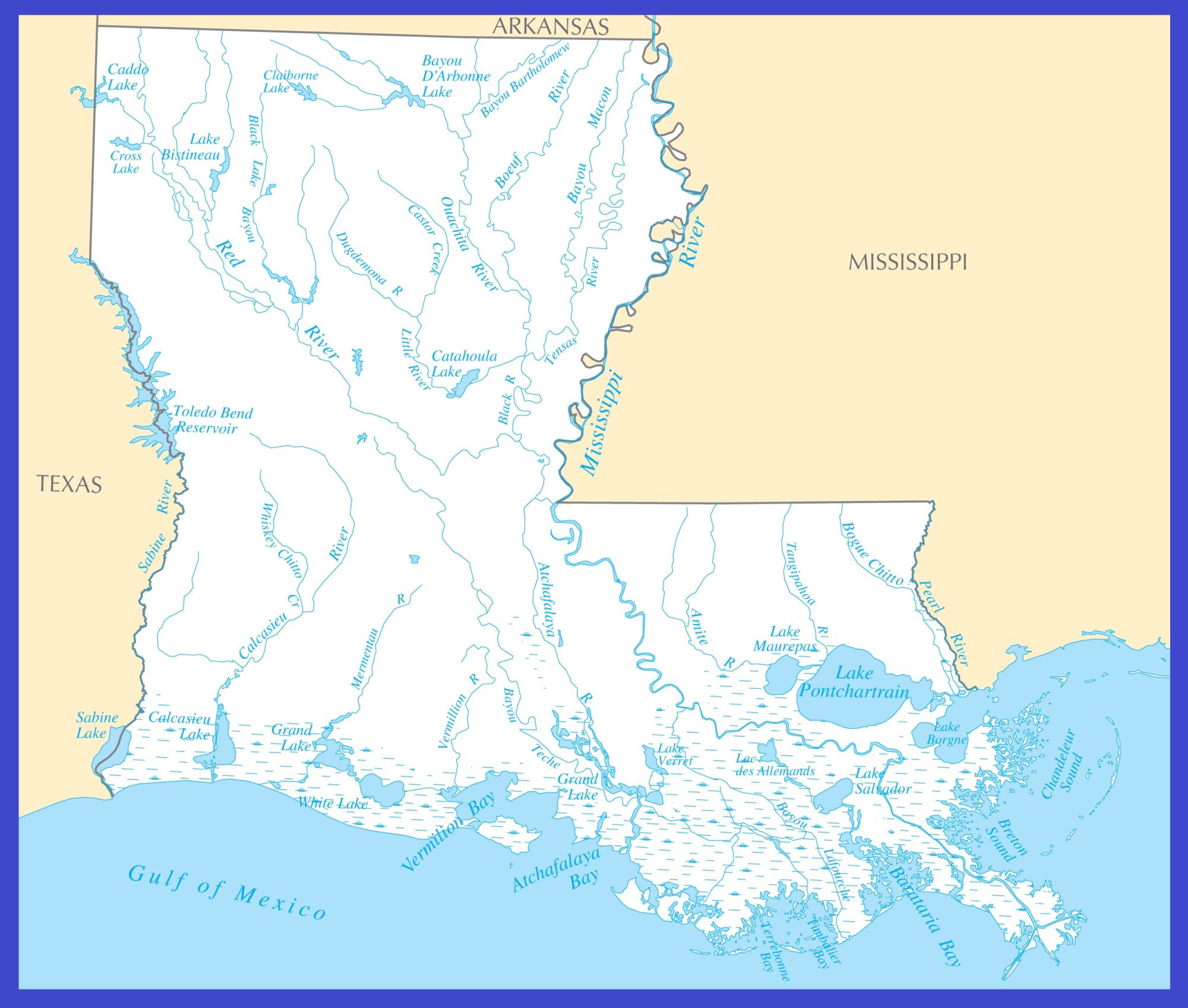
Geography Map of Louisiana

Louisiana is located in the southern region of the United States. It lies between Texas and Mississippi, and south of Arkansas. The Geography Map of Louisiana is the 31st largest map with an area of 50,000 square miles. Louisiana borders Texas to the west, Arkansas to the north, Mississippi to the east. The state features 4,800 km (3,000 mi) of shorelines along the Gulf of Mexico in the south.
Louisiana’s landscape is mostly flat. The highest point is Driskill Mountain at only 163 meters. It is the highest natural summit in the state, located 80 km (50 mi) east of Shreveport. The state’s geography offers a Coastal Marsh, Mississippi Floodplain. The state geography is divided into two parts, the uplands of the north, and the alluvial along the coast.
Important rivers are the Mississippi, the Atchafalaya, Ouachita, Pearl, Red, and Sabine. Lakes of size include the Charles, Grand, Pontchartrain, Sabine and White, and the Toledo Bend Reservoir.
Geography Facts
- Land Area: (land) 43,562 sq miles (water) 8,277 sq miles (TOTAL) 51,839 sq miles
- Horizontal Width: 266 miles
- Bordering States: (3) Arkansas, Mississippi, and Texas
- Parishes: (64) Map
- Highest Point: Driskill Mountain, 535 ft.
- Lowest Point: is along the Mississippi River in the city of New Orleans (-9 ft.)
- Mean Elevation: (average) 98 ft.
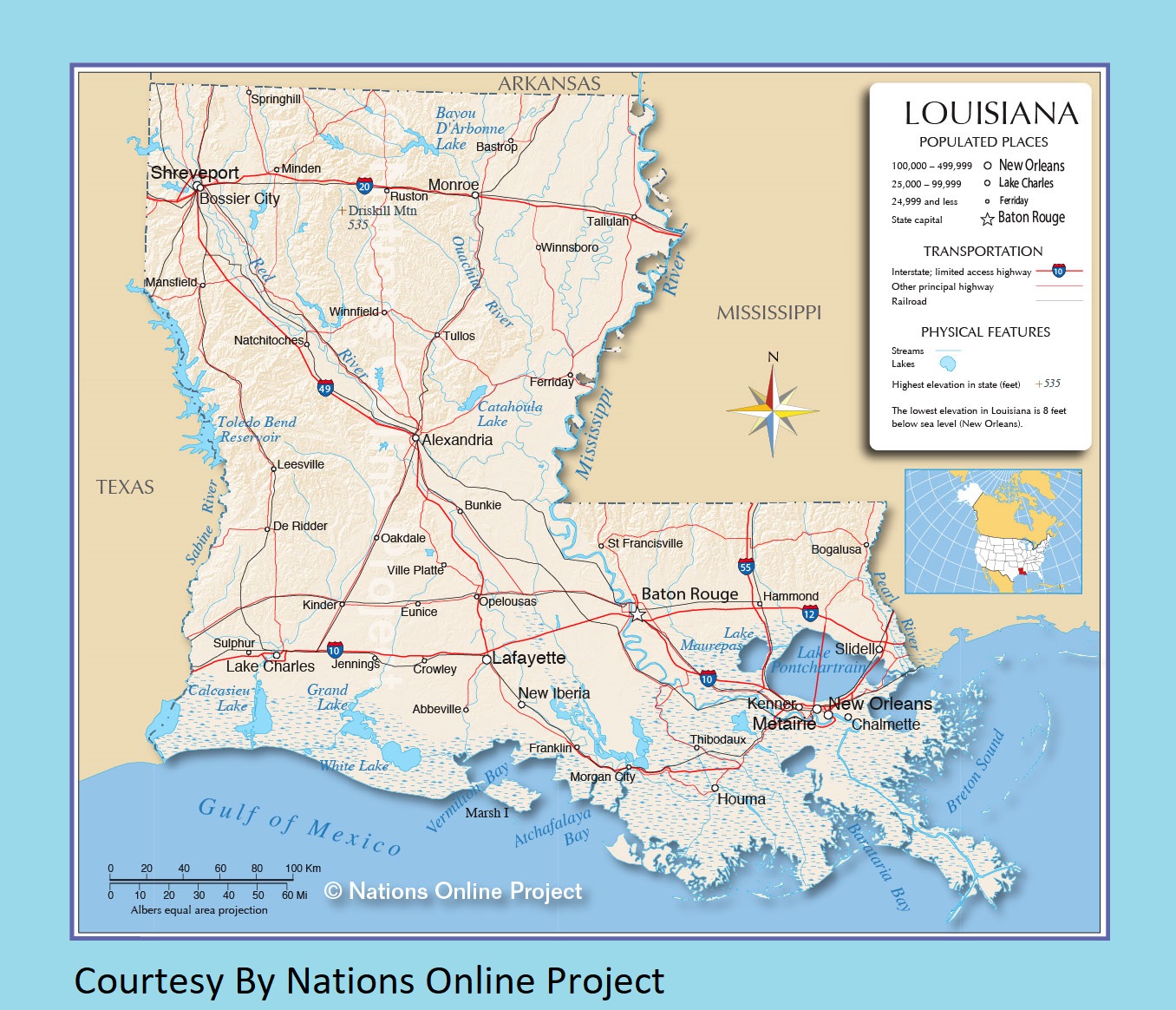
Transportation Map of Louisiana
![]()
The Louisiana Department of Transportation and Development is responsible for maintaining the Transportation Map of Louisiana. Major Interstate highways are I-10, I-110, I-210, I-310, I-510, I-610, I-910 (unsigned), I-12, I-20, I-220, I-49, I-55, I-59.
The busiest airports in the state are Louis Armstrong New Orleans International Airport and Baton Rouge Metropolitan Airport. Amtrak operates Crescent, Sunset Limited, and the City of New Orleans through the state.
Cities Map Map of Louisiana

The largest city is New Orleans (391,500). The second-largest city in Baton Rouge, the capital city, is 227,500. Other Cities are Shreveport (195,000), Metairie (138,500), Lafayette (127,600).
Other cities and towns in Louisiana:
Abbeville, Alexandria, Bastrop, Bogalusa, Bossier City, Bunkie, Chalmette, Crowley, De Ridder, Eunice, Ferriday, Franklin, Hammond, Houma, Jennings, Kenner (part of New Orleans metro), Kinder, Lake Charles, Leesville, Mansfield, Minden, Monroe, Morgan City, Natchitoches, New Iberia, Oakdale, Opelousas, Ruston, Slidell, Springhill, St. Francisville, Sulphur, Tallulah, Thibodaux, Tullos, Ville Platte, Winnfield, and Winnsboro.
Louisiana Transportation and physical map large printable
Louisiana Rivers Map | Large Printable High Resolution and Standard Map