Map of Mississippi | Political, County, Geography, Transportation, And Cities Map

Map of Mississippi | Political, County, Geography, Transportation, And Cities Map is the Map of Mississippi. You can also free download Map images HD Wallpapers for use desktop and laptop. Click Printable Large Map
Mississippi is situated in the Deep South region of the United States. This region is known as the ‘Dixie’ region. The Map of Mississippi is the 32nd largest of the 50 U.S. states with an area of 48,430 square miles. With 2.97 million people, It is also the 32nd most populous of the fifty states of the USA. Jackson is the state’s capital and largest city of Mississippi. The state was joined to the union on December 10, 1817, as the 20th state.
Many Indians tribes lived in Mississippi for thousands of years. It became a French colony in the first half of the 18th century. The French ceded the area to Britain in 1763. Mississippi is created from land ceded by Georgia and South Carolina After the American Revolution. The state joined to the union on December 10, 1817, as the 20th state.
Mississippi Facts
- Capital City: Jackson (pop.) 175,710 (2008 est.)
- Mississippi Population: 2,984,926 (2012 est.) (31st)
- Currency: U.S. Dollar
- Language: English, others
- Largest Cities: (by population) Jackson, Gulfport, Biloxi, Hattiesburg, Meridian, Greenville
- Statehood: December 10, 1817 (20th state)
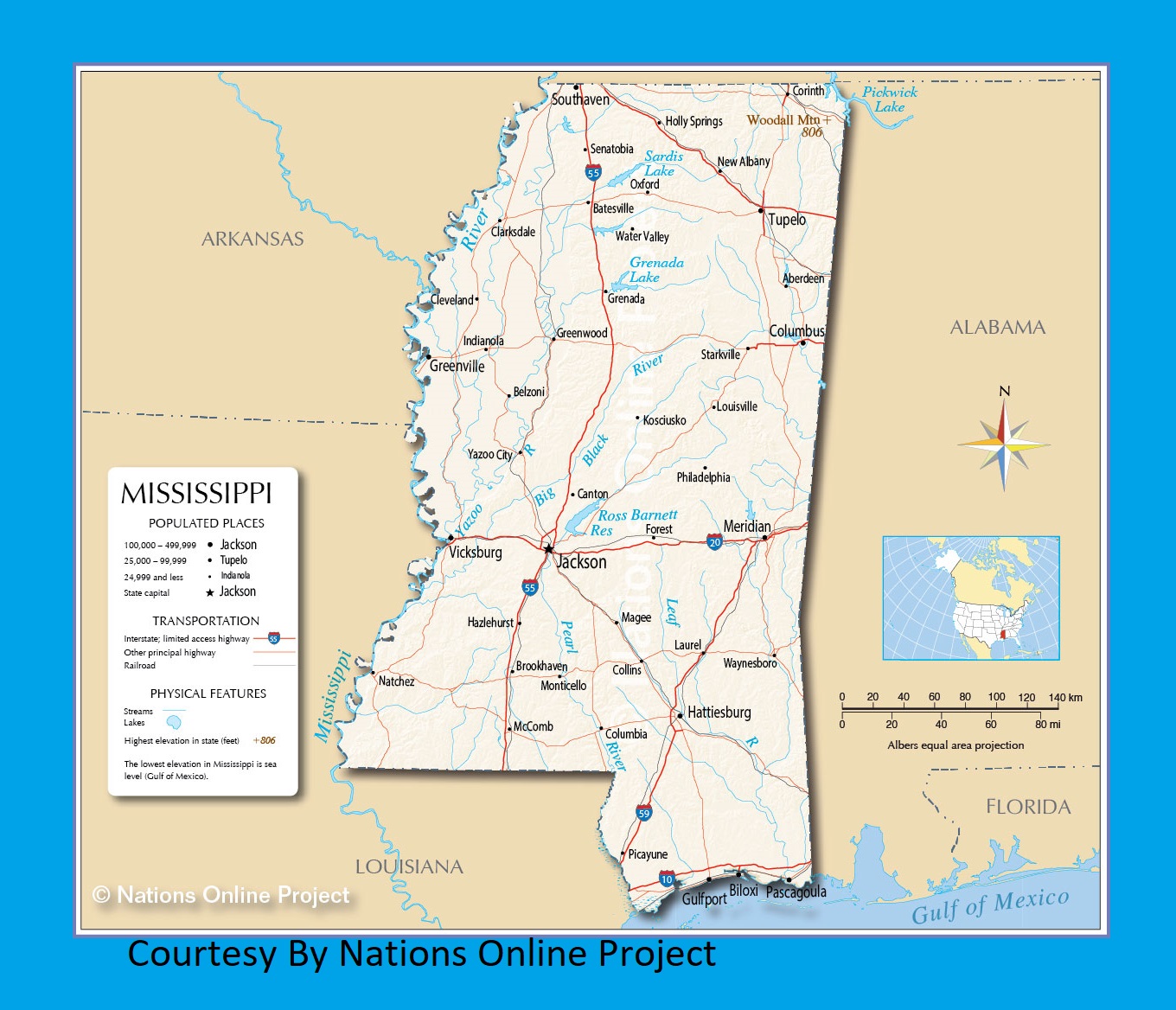
Political Map of Mississippi

Mississippi is located in the Southern United States. The Political Map of Mississippi shares border with Tennessee to the north, to the southwest by Louisiana and the Gulf of Mexico, to the east by Alabama, and to the west by Arkansas & Louisiana. Jackson is the state’s capital and largest city of Mississippi. The state has 82 counties. The Detailed Political Map shows the state of Mississippi with boundaries, the state capital Jackson, major cities and populated places, interstate highways, principal highways, and railroads.
County Map of Mississippi

There are 82 counties in the U.S. state of Mississippi. The biggest city and capital of Mississippi is Jackson which is the county seat of Hinds County. Yazoo County is the largest county of the state with an area of 920 sq mi (2,383 km2). The most populous county of the state is Hinds County with 245,285 people.
Geography Map of Mississippi

The name of the Mississippi state is derived from the Mississippi River that flows along its western boundary. It shares borders with Alabama, Tennessee, Louisiana, the Gulf of Mexico, and Arkansas. The Geography Map of Mississippi covers an area of 125,438 km² (48,432 sq mi). Woodall Mountain is the highest point in the state with an elevation of 246 meters.
Mississippi is located within two major regions in the United States: the Gulf Coastal Plain and the Mississippi Alluvial Plain. Central Mississippi is hilly, as the land gently rises from the Gulf of Mexico coastline to the far northeastern highlands. The northwest remainder of the state consists of the Mississippi Delta, a section of the Mississippi Alluvial Plain.
Mississippi’s major rivers are, besides the Mississippi, the Big Black River, The Pearl River which is the longest river that is entirely within Mississippi, and the Yazoo River. Major lakes include Ross Barnett Reservoir, Arkabutla Lake, Sardis Lake, and Grenada Lake with the largest lake being Sardis Lake.
Geography Facts
- Land Area: (land) 46,907 sq miles (water) 1,520 sq miles (TOTAL) 48,427 sq miles
- Bordering States: (4) Louisiana, Arkansas, Tennessee and Alabama
- Counties: (82) Map
- County: (largest by population) Hinds, 250,900
- Highest Point: Woodall Mountain 806 ft.
- Lowest Point: the Gulf of Mexico, 0 ft.
Transportation Map of Mississippi
![]()
There are six airports with commercial passenger service in Mississippi. Jackson–Evers International Airport and Gulfport–Biloxi International Airport are the busiest airports in the state. Mississippi has nine interstate highways: I-10, I-110, I-20, I-220, I-22, I-55, I-59, I-69, I-269. There are also fourteen main U.S. Routes in the state: US 11, US 45, US 49, US 51, US 61, US 72, US 78, US 278, US 80, US 82, US 84, US 90, US 98, US 425. Amtrak’s Crescent and City of New Orleans route serve the state.
Cities Map of Mississippi

The Map of Mississippi is the 32nd largest with an area of 48,430 square miles. With 2.97 million people, It is also the 32nd most populous of the fifty states of the USA. Jackson is the state’s capital and largest city of Mississippi.
Major Cities: Jackson (173,000), Gulfport (70,000), Southaven (50,000), Hattiesburg (47,000), Biloxi (45,000).
Other cities and towns in Mississippi:
Aberdeen, Batesville, Belzoni, Brookhaven, Canton, Clarksdale, Cleveland, Collins, Columbia, Columbus, Corinth, Forest, Greenville, Greenwood, Grenada, Hazlehurst, Holly Springs, Indianola, Kosciusko, Laurel, Louisville, Magee, McComb, Meridian, Monticello, Natchez, New Albany, Oxford, Pascagoula, Philadelphia, Picayune, Senatobia, Starkville, Tupelo, Vicksburg, Water Valley, Waynesboro, and Yazoo City.
Mississippi Transportation and physical map large printable
Mississippi Rivers Map | Large Printable Rivers Map of Mississippi


