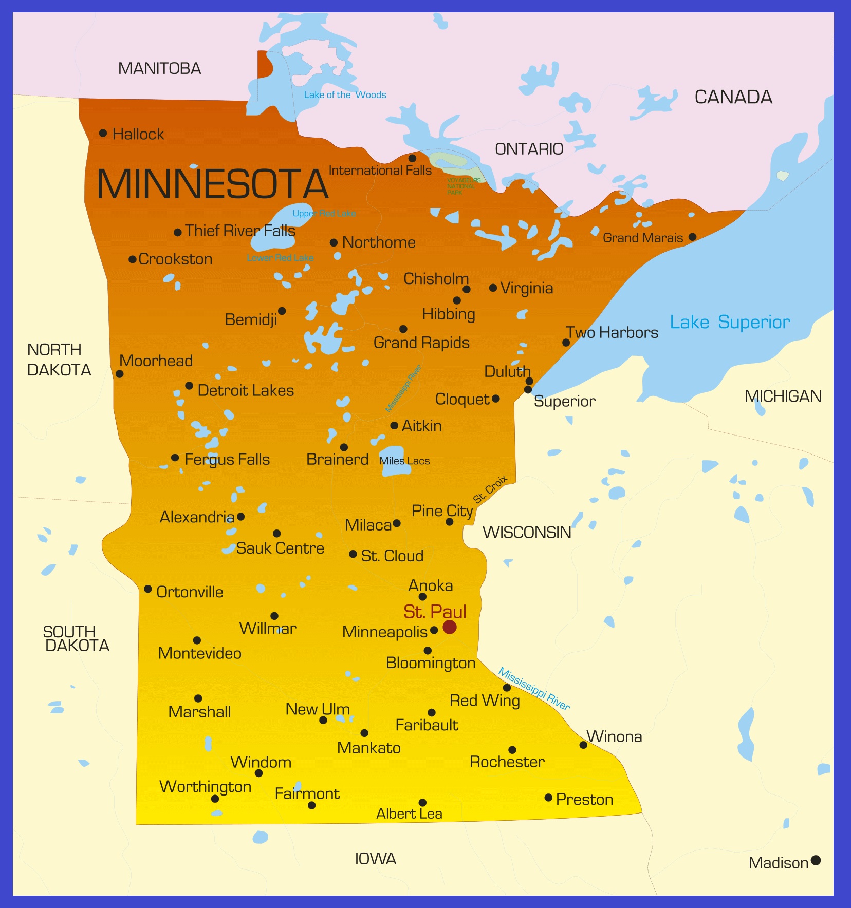
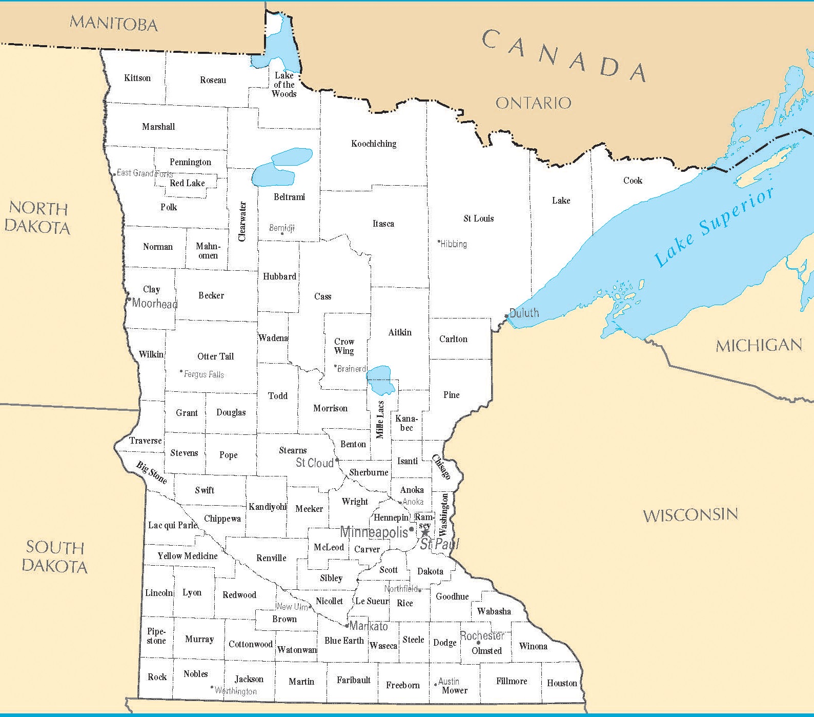
Map of Minnesota | Political, County, Geography, Transportation, And Cities Map

Map of Minnesota | Political, County, Geography, Transportation, And Cities Map is the Map of Minnesota. You can also free download Map images HD Wallpapers for use desktop and laptop. Click Printable Large Map
Minnesota is one of the 50 US state located in the western part of the Great Lakes Region. The state joined the union on May 11, 1858, as the 32nd state. Minnesota has over 10,000 Lakes giving the state Nicknamed the “Land of 10,000 Lakes”. The name Minnesota’s is taken from the Dakota Indians’ word for “sky-tinted water.”
The Map of Minnesota is the 12th largest state with an area of 225,181 km² (86,939 sq mi). It has a population of 5.61 million people. About 55% of Minnesota residents live in the Minneapolis–Saint Paul metropolitan area. It is the largest area of transportation, business, industry, education, and government in the state.
Various indigenous peoples inhabited Minnesota for thousands of years before Europeans arrived. Later it was ceded to Britain by the French in 1763, and 20 years later acquired by the US in 1783. It officially became the 32nd state on May 11, 1858.
Minnesota Facts
- Capital City: Saint Paul (pop.) 277,251 (2008 est.)
- Minnesota Population: 5,379,139 (2012 est.) (21st)
- Currency: U.S. Dollar
- Language: English, others
- Largest Cities: (by population) Minneapolis, Saint Paul, Duluth, Rochester, Bloomington, Brooklyn Park
- Statehood: May 11, 1858 (32nd state)
- Largest city: Minneapolis
- Largest metro: Minneapolis–Saint Paul
Political Map of Minnesota

Minnesota is located in the western part of the Great Lakes Region. The Political Map of Minnesota is the 12th largest state with an area of 225,181 km² (86,939 sq mi). The state shares borders with the Canadian provinces of Ontario and Manitoba in the north, Lake Superior and Wisconsin on the east, North Dakota and South Dakota in the west, Iowa is to the south. There are 87 counties in Minnesota. The capital of Minnesota is Saint Paul and it is also the largest city of the state.
County Map of Minnesota

There are 87 counties in the County Map of Minnesota. it also has several historical counties. On October 27, 1849, The state is divided into 9 Counties: Benton, Dahkotah, Itasca, Ramsey, Mahkahta, Pembina, Wabasha, Washington, and Wahnata.
When Minnesota was declared as a state, 57 of the present 87 counties were established. The last county is Lake of the Woods County in 1923. St. Louis County is the largest county in Minnesota with an area of 6,225.16 sq mi (16,123 km2). Hennepin County is the most populous county in Minnesota with a population of 1,152,425.
Geography Map of Minnesota

Minnesota is located in the Upper Midwestern United States. It comprises an area of 86,943 square miles. The state shares borders with the Canadian provinces of Ontario and Manitoba in the north, Lake Superior and Wisconsin on the east, North Dakota and South Dakota in the west, Iowa is to the south. Eagle Mountain is the highest point in Minnesota at 701 m (2,301 ft). It is located in the Arrowhead Region within the Superior National Forest.
The state features 6,564 natural rivers and more than 11,000 lakes over 10 acres in size. Some of the largest lakes besides Lake Superior are the Lake of the Woods (partly in Canada), the Leech Lake, Mille Lacs, Lake Winnibigoshish, and the Upper and Lower Red Lake.
Minnesota’s most important river is the Mississippi. It starts from northwestern Minnesota, then flows south to the Gulf of Mexico, just below the city of New Orleans. Other major rivers are the Minnesota, Rainy, Red, and St. Croix.
Geography Facts
- Land Area: ( land) 79,610 sq miles ( water) 7,326 sq miles ( TOTAL) 86,936 sq miles
- Bordering States: (4) North Dakota, South Dakota, Iowa, and Wisconsin
- Counties: (87) Map
- County: (largest by population) Hennepin, 1,116,200
- Highest Point: Eagle Mt., 2,301 ft.
- Lowest Point: Surface of Lake Superior, 602 ft.
Transportation Map of Minnesota

The Transportation Map of Minnesota is overlooked by the Minnesota Department of Transportation. Interstate 35 (I-35), I-90, and I-94 are primary interstate highways in Minnesota. The busiest airport in the state is Minneapolis–St. Paul International Airport. Most other domestic carriers serve the airport. Amtrak operates Empire Builder through Winona, Red Wing, Saint Paul, Staples, and Detroit Lakes.
Cities Map of Minnesota

The capital of Minnesota is Saint Paul. Minneapolis is the largest city in the state with an estimated population of 413,651 people. There are 17 cities in Minnesota that have populations of more than 50,000 people. Rochester (117,000), Bloomington (86,000), Duluth (86,000) are other major cities.


