Map of New Hampshire | Political, County, Geography, Transportation, And Cities Map

Map of New Hampshire | Political, County, Geography, Transportation, And Cities Map is the Map of New Hampshire. You can also free download Map images HD Wallpapers for use desktop and laptop. Click Printable Large Map
The Map of New Hampshire is the 5th smallest state by land area in the United States with an area of 24,214 km². It is located in the New England region of the northeastern United States. The state is the 41st most populous state of the country with a population of 1.35 million people. New Hampshire shares borders with Maine, Massachusetts, Vermont, and Canada. Concord is the official state capital of New Hampshire, while Manchester is the largest city of the state.
The Algonquian and other tribes inhabited this land for many years before the first European settlers arrived in 1600. English colonized this land in the early 1600s. Scattered communities agreed to become a part of the Massachusetts colony in 1639.
After some years, it was permanently separated from Massachusetts, becoming the Royal Province (colony) of New Hampshire. The province became a state in 1776 and ratified the US Constitution on 21st June 1788. It was the ninth and last necessary state to ratify the new Constitution of the United States.
- Capital City: Concord (metro pop.) 42,392 (2008 est.)
- New Hampshire Population: 1,320,718 (2012 census) (42nd)
- Currency: U.S. Dollar
- Language: English, others
- Largest Cities: (by population) Manchester, Nashua, Concord, Derry, Rochester, Salem
- Statehood: June 21, 1788 (9th state)
Political Map of New Hampshire

New Hampshire is located in the New England region of the northeastern United States. It shares an international border with the Québec province of Canada to the north and northwest and Massachusetts to the south, Vermont to the west, Maine, and the Atlantic Ocean to the east. Concord is the state capital of New Hampshire, while Manchester is the largest city of the state. The state’s nickname is “The Granite State”.
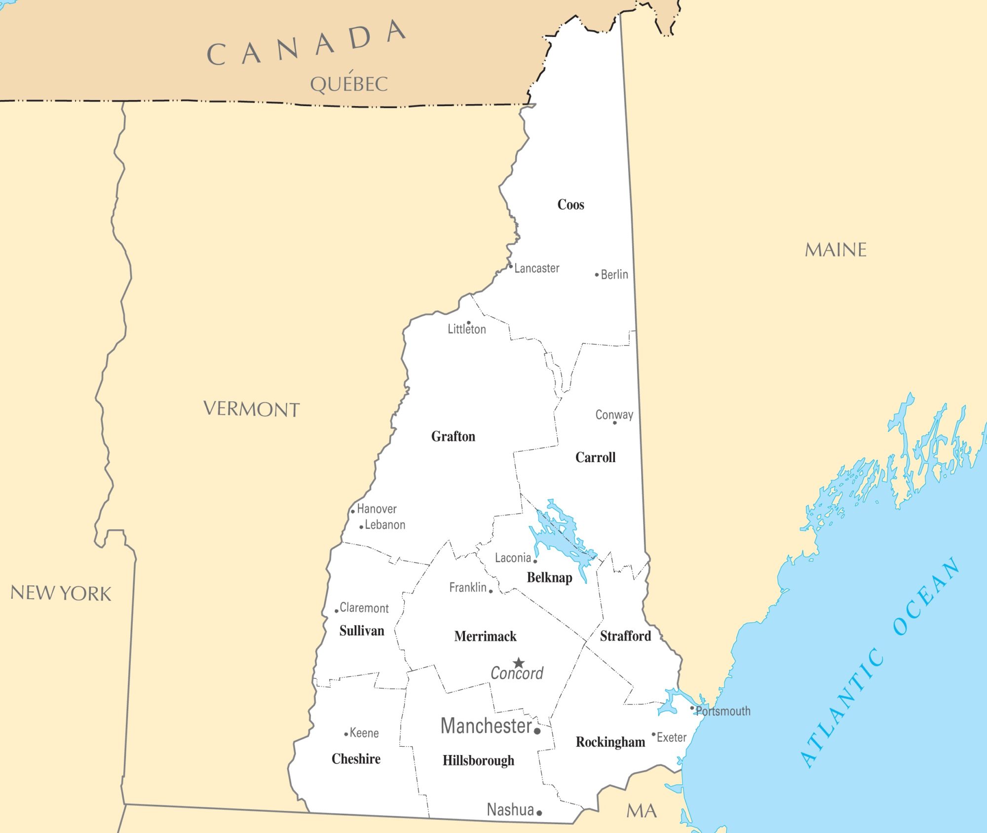
County Map of New Hampshire

There are 10 counties in the County Map of New Hampshire. Five of the counties from 1769. The last counties created are Belknap County and Carroll County. These counties form a strong platform for governance at the local level. The counties are administered by separate county seats. Hillsborough County is the most populous county in the state with a population of 406,678. Coös County is the largest county in New Hampshire by area.
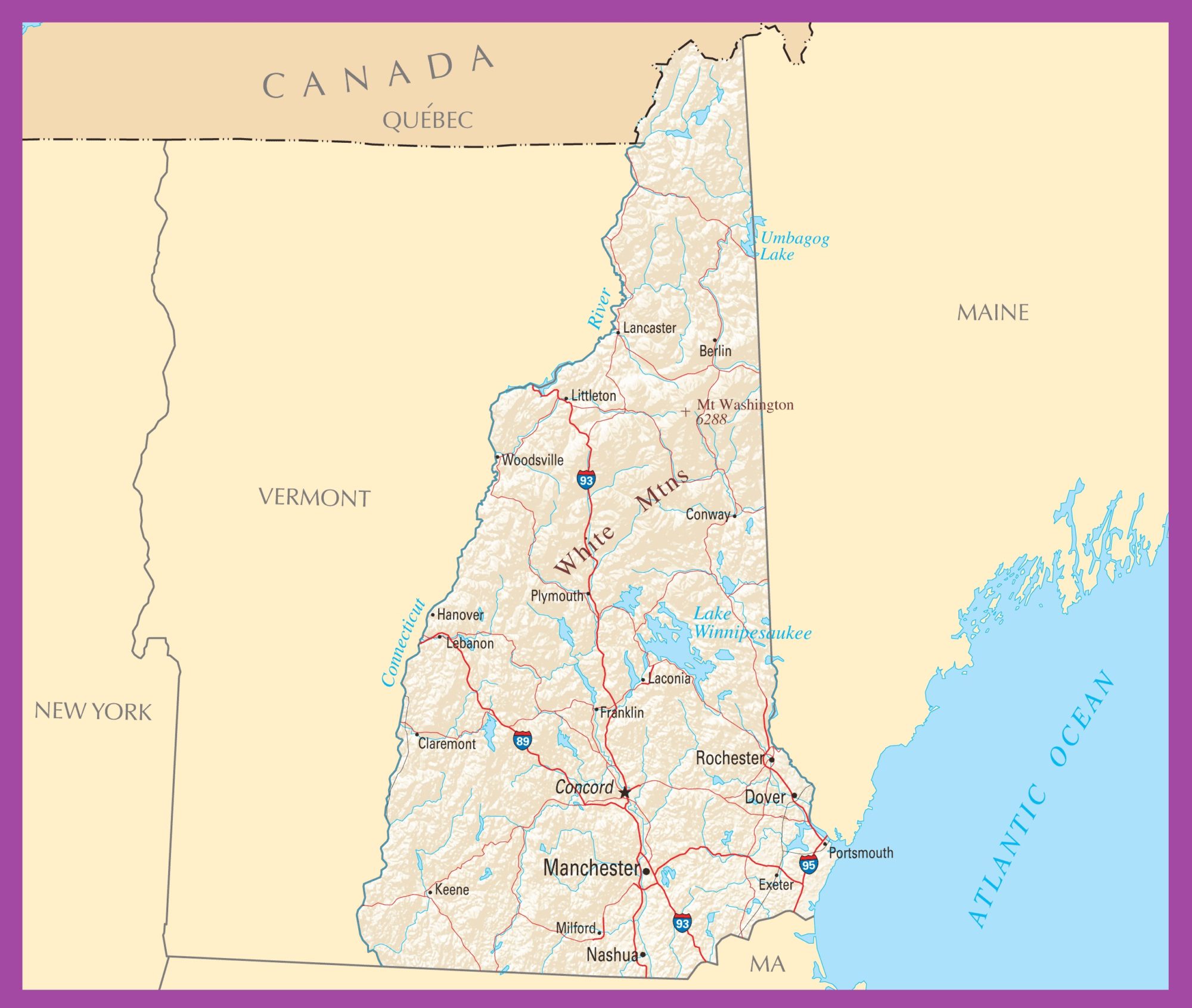
Geography Map of New Hampshire

New Hampshire is located in the New England region of the northeastern United States. It is the 5th smallest state by land area in the United States with an area of 24,214 km². It shares an international border with the Québec province of Canada to the north and northwest and Massachusetts to the south, Vermont to the west, Maine, and the Atlantic Ocean to the east. Mount Washington is the highest point in the state with a height of around 1916 meters.
There are seven major regions in New Hampshire Geography Map. The region is the Great North Woods, the Lakes Region, the White Mountains, the seacoast, the Merrimack Valley, the Monadnock Region, and the Dartmouth-Lake Sunapee area.
To the south of the White Mountains and the Sandwich Range is the New Hampshire’s Lakes Region. Major lakes are surrounding Lake Winnipesaukee, Winnisquam Lake, Squam Lake, and Newfound Lake. Lakes Region is a popular tourist destination in the summertime.
Transportation Map of New Hampshire

New Hampshire has a well-maintained Interstate highway, U.S. highways, and state highways. I-89, I-93, and I-95 are the major interstate highways in New Hampshire. U.S. Route 1, Route 2, Route 3, Route 4 are other major highways of the state. The largest airport in the state is Manchester-Boston Regional Airport in the south of Manchester NH. Amtrak operates Vermonter and Downeaster routes through the state.
Cities Map of New Hampshire

Concord is the state capital of New Hampshire, while Manchester is the largest city of the state. Largest cities in New Hampshire: Manchester (110,000), Nashua (68,000), Concord (42,000), Derry (33,000), Dover (30,000), Rochester (30,000)
Other cities and towns in New Hampshire:
Berlin, Claremont, Conway, Exeter, Franklin, Hanover, Keene, Laconia, Lancaster, Lebanon, Littleton, Milford, Plymouth, Portsmouth, and Woodsville.


