Border Map of India | International Indian Border Map

A borderline is a dividing line that marks the territorial limits between the two countries. Border Map of India Shows the dividing line that marks the Indian border with other countries.
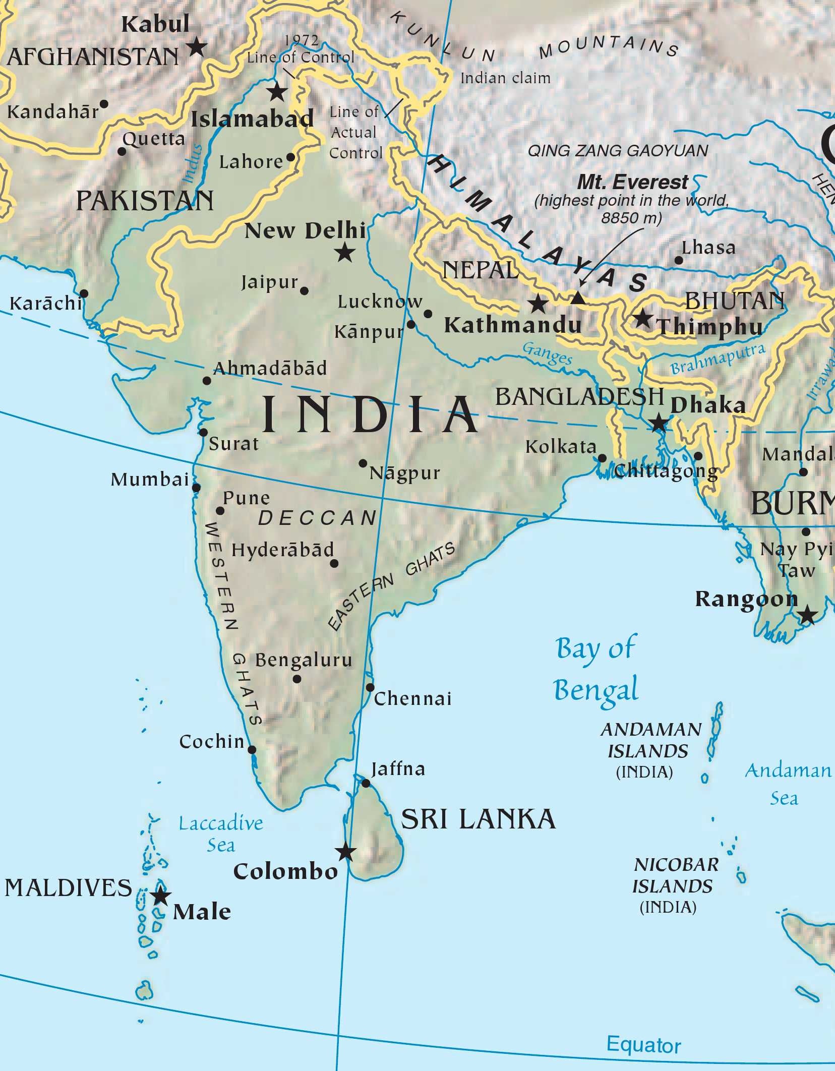
The Republic of India is a country in South Asia. It is the seventh-largest country by geographical area, the second-most populous country, and the largest democracy in the world. India has a coastline of over 7,516 kilometers, bounded by the Indian Ocean on the south, the Arabian Sea on the west, and the Bay of Bengal on the east. India shares land borders with ► Pakistan to the north-west; ► China (with ► Tibet), ► Nepal to the north; and ► Bangladesh, ► Bhutan to the north-east; and ► Myanmar to the east. In the Indian Ocean, India is in the vicinity of ► Sri Lanka, ► Maldives and ► Indonesia are to the south.
Some International Borders of India
1. India and Pakistan (3,233 kilometers)
Punjab
Rajasthan
Gujarat
Jammu and Kashmir
2. India and China (3,488 kilometers)
Sikkim
Jammu and Kashmir
Uttarakhand
Arunachal Pradesh
Himachal Pradesh
3. India and Nepal (1751 kilometers)
Uttar Pradesh
Uttarakhand
West Bengal
Bihar
Sikkim
4. India and Bhutan (699 kilometers)
West Bengal
Sikkim
Assam
Arunachal Pradesh
5. India and Myanmar (1643 kilometers)
Manipur
Arunachal Pradesh
Nagaland
Mizoram
6. India and Bangladesh (4,096 kilometres)
Meghalaya
Assam
Tripura
Mizoram
West Bengal
7. India and Afghanistan (106 kilometers)
Jammu and Kashmir
8. India and Indonesia
Andaman and Nicobar Islands
Border Map of India | International Indian Border Map is the Map of India . You can also free download Map images HD Wallpapers for use desktop and laptop.
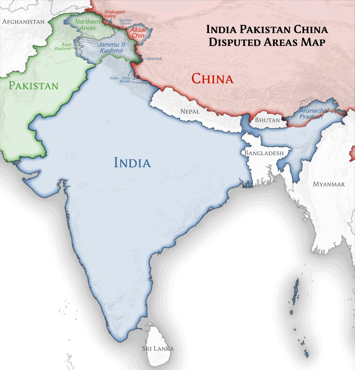
India and Pakistan were one nation before the partition took place in 1947. After the partition, India was divided into two separate countries Named India and Pakistan. There is an international border that runs between India and Pakistan and demarcates the states of India from the four provinces of Pakistan. In total, India shares 3,323 km of its land border with Pakistan that includes the Line of Control (LoC) in Jammu and Kashmir. The Border Map of India and Pakistan also displays countries that border both the countries like China that borders India and Tajikistan and Afghanistan that border Pakistan.
Some Important International Border On India
McMahon Line
the McMahon line is a demarcation that separates Tibet and north-east India. Colonel McMahon had proposed this line as the boundary between Tibet, China, and India at the Shimla Convention of 1914. China, however, disputes the validity of the McMahon line. It claims that Tibet isn’t a sovereign government, and therefore any treaty made with Tibet stands invalid.
Radcliffe Line
Radcliffe Line divided British India into India and Pakistan. The Radcliffe Line was drawn between West Pakistan (now Pakistan) and India on the western side and between India and East Pakistan (now Bangladesh) on the eastern side of the subcontinent.
Durand Line
Boundary line between India and Afghanistan demarcated by Sir Mortimer Durand. It separated British India and Afghanistan. After partition, Pakistan inherited this line. However, a short section of the Afghanistan border is shared with the Indian state of Jammu and Kashmir.
Line of Actual Control (LAC)
Line of Actual Control is the demarcation line between India and China which separates the India controlled territory from the China-controlled territory in the former princely state of Jammu and Kashmir.