Map of India | Printable Map of India With States Names

India is a country in South Asia. It is the seventh-largest country by area, the second-most populous country with over 1.3 billion people, and the most populous democracy in the world. India is a federal republic with a parliamentary system of government. The capital of India is New Delhi, while its most populous city is Mumbai. The official languages of India are Hindi and English.
India is a land of diverse cultures, religions, and languages. It is home to Hinduism, Buddhism, Jainism, Sikhism, Islam, and Christianity. India is also home to a wide variety of ethnic groups, including the Aryans, Dravidians, and Mongoloids. India is a major economic power. It is the world’s sixth-largest economy by nominal GDP and the third-largest by purchasing power parity (PPP). India is also a major exporter of software, textiles, and other goods.
India is a nuclear-armed state and a member of the United Nations, the G20, the Commonwealth of Nations, and the Shanghai Cooperation Organisation. This Post Includes a Printable Large Attractive HD Map With Indian States’ Names. You Can Download All Type Of Map About India From This Post.
India Map Facts
- Area: 3,287,263 square kilometers (1,269,345 sq mi)
- Population: 1,380,000,000 (2023 est.)
- Capital: New Delhi
- Largest city: Mumbai
- Official languages: Hindi, English
- Currency: Indian rupee (₹)
- National anthem: Jana Gana Mana
- National symbol: Tiger
India Map With States Names

State Information |
|
|---|---|
| Feature | State |
| Largest state (in terms of area) | Rajasthan |
| Smallest state | Goa |
| Most populous state | Uttar Pradesh |
| Least populous state | Sikkim |
| Most populous union territory (not incl Delhi) | Puducherry |
| Least populous union territory | Lakshadweep |
| Most densely populated state | Bihar |
| Least densely populated state | Arunachal Pradesh |
| First state to be formed on linguistic basis | Andhra Pradesh |
| Most literate state | Kerala |
| Least literate state | Bihar |
| The state with the longest coastline | Gujarat |
| The state has boundaries with seven states and two countries | Assam |
| The state surrounded on three sides by Bangladesh | Tripura |
| The state is surrounded by three countries and one state | Sikkim |
| The number of states which have a coastline | Nine |
| The number of Union Territories which have a coastline | Four |
| The states which have neither an international boundary nor a coastline | M.P., Chhattisgarh, Jharkhand, Haryana |
Northern India
-
Jammu and Kashmir: Known as the “Crown Jewel of India,” Jammu and Kashmir is a breathtaking region adorned with snow-capped mountains, pristine lakes, and lush valleys. It’s home to the iconic Taj Mahal, a UNESCO World Heritage Site that stands as a testament to love and architectural brilliance.
-
Ladakh: Often referred to as “Little Tibet,” Ladakh is a high-altitude desert with surreal landscapes, including the Pangong Tso Lake and the Hemis National Park. It’s a haven for adventure seekers, offering activities like trekking, camping, and white-water rafting.
-
Himachal Pradesh: Nicknamed the “Land of the Gods,” Himachal Pradesh is a mountainous paradise, home to the majestic Himalayas, lush green valleys, and hill stations like Shimla and Dalhousie, which provide a respite from the summer heat.

Central India
-
Madhya Pradesh: Known as the “Heart of India,” Madhya Pradesh is a land of ancient forts, serene temples, and rich wildlife sanctuaries. It’s home to the iconic Khajuraho temples, renowned for their intricate carvings and erotic sculptures.
-
Rajasthan: The “Land of Kings,” Rajasthan is a vibrant tapestry of deserts, palaces, and colorful festivals. It’s home to the Thar Desert, the Pink City of Jaipur, and the iconic Taj Mahal, a UNESCO World Heritage Site.
-
Gujarat: A land of contrasts, Gujarat is home to the bustling commercial city of Ahmedabad, the serene beaches of Diu, and the ancient Rann of Kutch, a vast salt desert that transforms into a shimmering white wonderland during the monsoon season.
Eastern India
-
West Bengal: Known for its rich cultural heritage and vibrant festivals, West Bengal is home to the iconic Kolkata, a city of colonial architecture and intellectual fervor. It’s also the gateway to the Sundarbans, the world’s largest mangrove forest, home to the Bengal tiger.
-
Odisha: Known for its ancient temples, colorful festivals, and stunning beaches, Odisha is home to the Konark Sun Temple, a UNESCO World Heritage Site, and the Puri Jagannath Rath Yatra, one of the world’s largest chariot festivals.
-
Sikkim: Nestled in the Himalayas, Sikkim is a land of snow-capped mountains, pristine lakes, and Buddhist monasteries. It’s home to Kanchenjunga, the world’s third-highest peak, and the enchanting Yumthang Valley, known for its carpets of flowers.
Southern India
-
Tamil Nadu: Known for its rich cultural heritage, ancient temples, and serene beaches, Tamil Nadu is home to the iconic Brihadeeswarar Temple in Thanjavur, a UNESCO World Heritage Site, and the Marina Beach in Chennai, the second-longest urban beach in the world.
-
Kerala: Known as “God’s Own Country,” Kerala is a paradise on Earth, adorned with lush green hills, backwaters, and pristine beaches. It’s home to Ayurveda, an ancient Indian system of medicine, and the enchanting Kumarakom Backwaters, a haven for nature lovers.
-
Karnataka: Known for its historical monuments, vibrant festivals, and stunning natural beauty, Karnataka is home to the iconic Hampi ruins, a UNESCO World Heritage Site, and the majestic Mysore Palace, a symbol of opulence and grandeur.
✅How Many State In India?
India is a federal union made up of 28 states and 8 union territories, totaling 36 separate entities. The 1st state of India, Andhra State was created On October 1, 1953. Varanasi is India’s oldest continually inhabited city.
✅Indian Map With State Names
The 28 states in India are as follows: Andhra Pradesh, Arunachal Pradesh, Assam, Bihar, Chhattisgarh, Goa, Gujarat, Haryana, Himachal Pradesh, Jharkhand, Karnataka, Kerala, Madhya Pradesh, Maharashtra, Manipur, Meghalaya, Mizoram, Nagaland, Odisha (Orissa), Punjab, Rajasthan, Sikkim, West Bengal, Tamil Nadu, Telangana, Tripura, Uttar Pradesh, and Uttarakhand.
Map of India | Printable Map of India With States Names is the Map of India . You can also free download Map images HD Wallpapers for use desktop and laptop.
Political Large Map of India
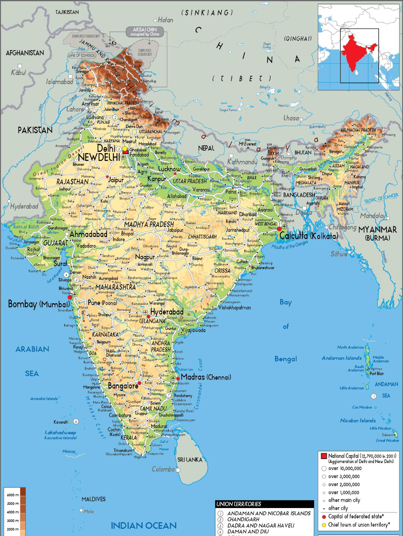
The Political Large Map of India is a useful tool, showing India and its neighboring countries - Pakistan, China, Nepal, Bhutan, Bangladesh, Myanmar, and Sri Lanka. T Not only that, one can use the map to easily spot different rivers and oceans such as the Arabian Sea, Bay of Bengal, and the Indian Ocean.
Printable Blank Outline Map of India
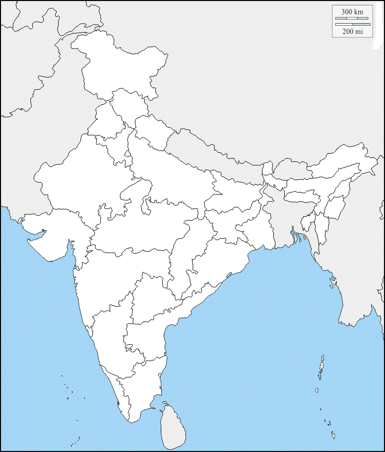
The Printable Blank Outline Map of India is a useful tool, showing India and its neighboring countries - Pakistan, China, Nepal, Bhutan, Bangladesh, Myanmar, and Sri Lanka. T Not only that, one can use the map to easily spot different rivers and oceans such as the Arabian Sea, Bay of Bengal, and the Indian Ocean.
HD Map of India
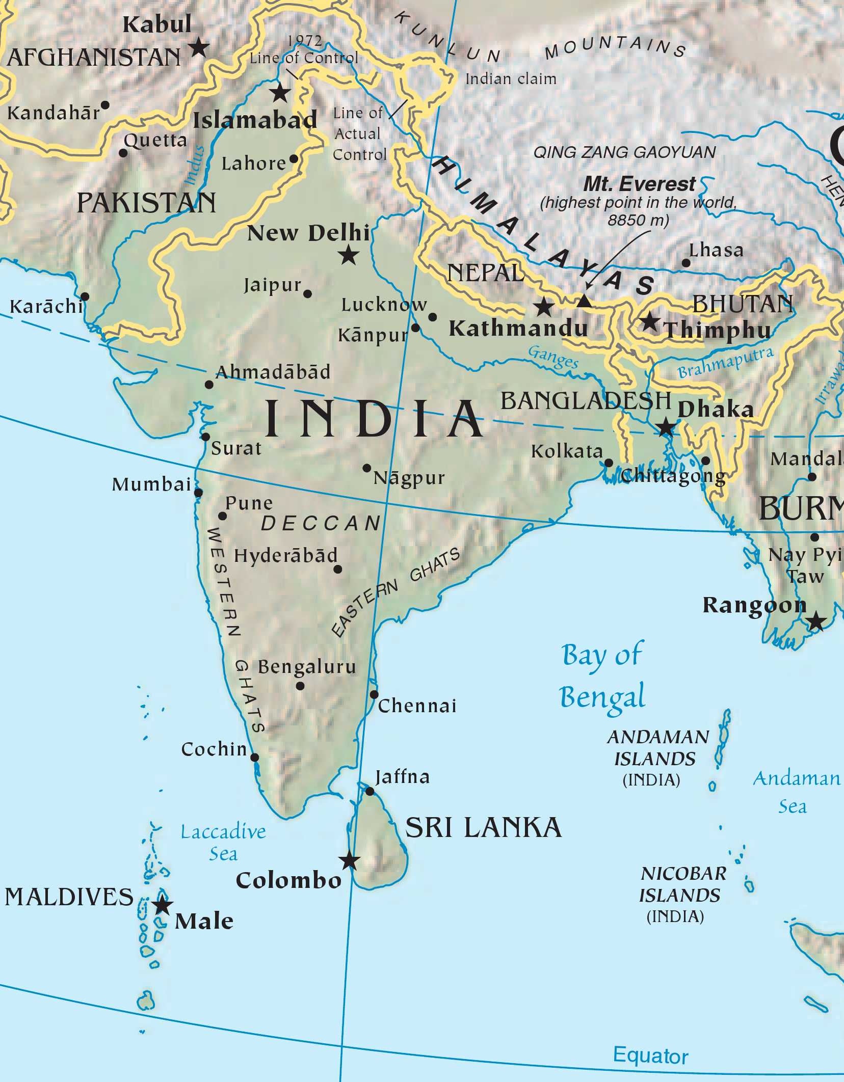
The HD Map of India is useful for travelers, researchers, students, or anybody who wants to get acquainted with the country.
India Map With State Names
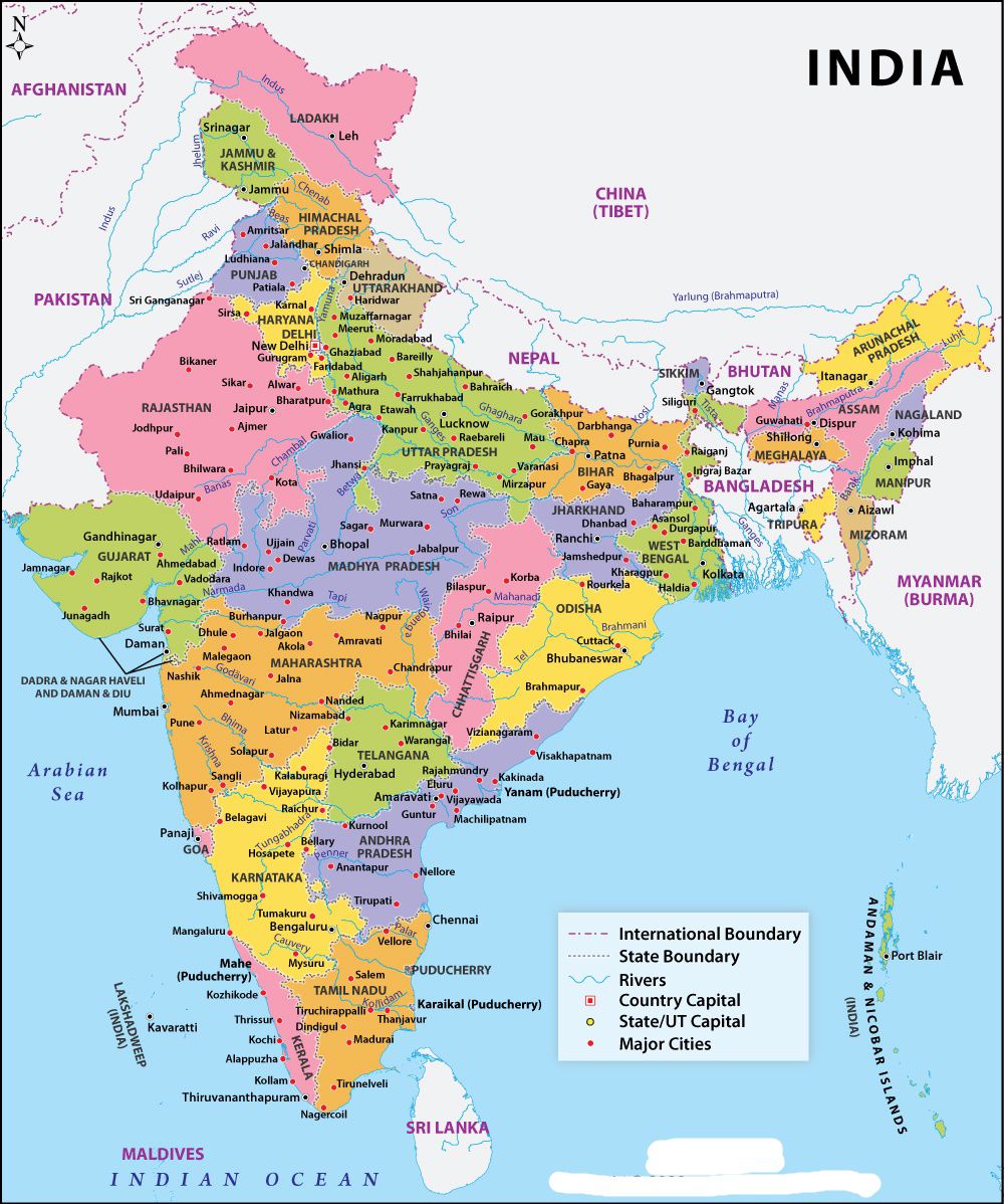
The India Map With State Names is useful for travelers, researchers, students, or anybody who wants to get acquainted with the country.